
Magnitude |
:3 |
| Date & Time (UTC) | 2015-09-17 10:10:51.9 |
| Date & Time (Local) | 1394/6/26 14:40:51.9 |
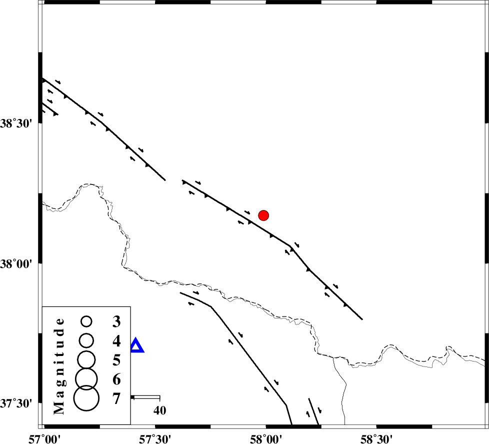
| Location | Lat:38.171 Lon: 57.989 |
| Region | Turkmenistan, 42 km North-West of Ashgabat |
Nearest Cities |
|
| 42 km North West of Ashgabat, Turkmenistan Province | |
| 51 km North of Kuseh, Khorasan(north) Province | |
| 52 km North East of Yangi ghale-ye bala, Khorasan(north) Province | |
| 54 km North East of Gifan olia, Khorasan(north) Province | |
| 63 km North East of Tukur, Khorasan(north) Province | |
| Depth | 23 km |
| Agency | |
Faults within 150 km: |
|
| MAIN_KOPEHDAGH_F3 (Length: 96 km) , Distance to epicenter: 6 km | |
| MAIN_KOPEHDAGH_F2 (Length: 131 km) , Distance to epicenter: 41 km | |
| BAGHAN_GERMAB_F (Length: 79 km) , Distance to epicenter: 42 km | |
| Number of Phases | 5 |
| RMS | 0.2 |
| Number of Stations | 3 |
| Error in Latitude | >6.2 km |
| Error in Longitude | 6.8 km |
| Error in Depth | 7.9 km |
Download waveform in seisan format
to download seisan software Click here
to access information about IIEES stations Click here
Amplitude | ||||||||
| UID | Agency | Station | Component | Amplitude | Period | Arrival Time | Proccessing Time | Signal Clip |
| 100975 | IIEES | BJRD | E | 458.6 | 0.17 | 2015-09-17 10:11:14 | 2015-09-19 07:47:00 | n |
| 100976 | IIEES | MRVT | E | 395.9 | 0.23 | 2015-09-17 10:11:44 | 2015-09-19 07:47:00 | n |
| 100977 | IIEES | SHRO | E | 43.4 | 0.33 | 2015-09-17 10:12:30 | 2015-09-19 07:47:00 | n |
Phase | ||||||||||||
| Agency | Station | Component | Phase Type | Phase Quality | First Motion | Observed Arrival Time | Time Residual | Loc. Flag | Input Weight | Distance | Azimuth | |
| IIEES | BJRD | Z | Pg | E | 2015-09-17 10:11:05 | 0.29 | y | 73.1 | 224 | |||
| IIEES | BJRD | E | Sg | E | 2015-09-17 10:11:13 | -0.17 | y | 73.1 | 224 | |||
| IIEES | MRVT | Z | Pg | E | 2015-09-17 10:11:20 | -0.29 | y | 176 | 252 | |||
| IIEES | MRVT | N | Sg | E | 2015-09-17 10:11:41 | 0.17 | y | 176 | 252 | |||
| IIEES | SHRO | Z | Pn | E | 2015-09-17 10:11:35 | 0 | y | 297 | 217 | |||