
Magnitude |
:3 |
| Date & Time (UTC) | 2015-09-17 01:11:42.0 |
| Date & Time (Local) | 1394/6/26 05:41:42.0 |
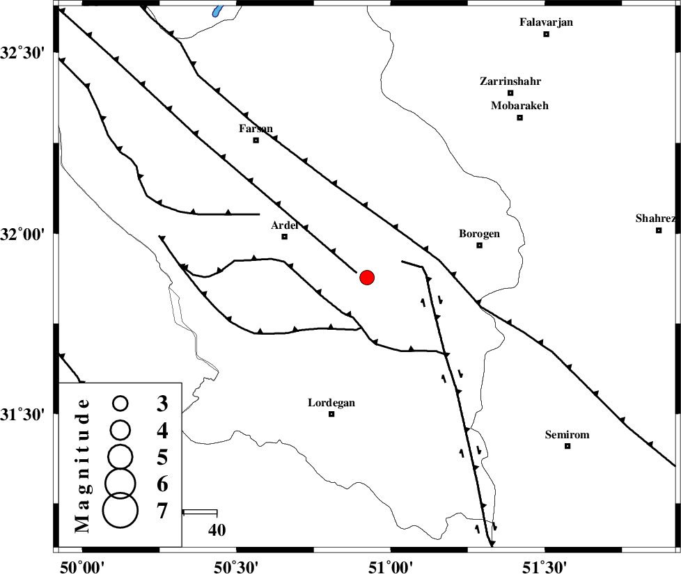
| Location | Lat:31.878 Lon: 50.923 |
| Region | Chaharmahal Bakhtiari Province, 28 km South-East of Ardel |
Nearest Cities |
|
| 13 km West of Baladaji, Chaharmahal Bakhtiari Province | |
| 19 km East of Naghan, Chaharmahal Bakhtiari Province | |
| 21 km South East of Shalamzar, Chaharmahal Bakhtiari Province | |
| 22 km North West of Gandoman, Chaharmahal Bakhtiari Province | |
| 28 km South East of Ardel, Chaharmahal Bakhtiari Province | |
| Depth | 15 km |
| Agency | |
Faults within 150 km: |
|
| ARDAL_F (Length: 170 km) , Distance to epicenter: 3 km | |
| DENA_F (Length: 137 km) , Distance to epicenter: 12 km | |
| DOPOLAN_F (Length: 107 km) , Distance to epicenter: 13 km | |
| Number of Phases | 5 |
| RMS | 0.7 |
| Number of Stations | 5 |
| Error in Latitude | >7.4 km |
| Error in Longitude | 7.5 km |
| Error in Depth | 0 km |
Download waveform in seisan format
to download seisan software Click here
to access information about IIEES stations Click here
Amplitude | ||||||||
| UID | Agency | Station | Component | Amplitude | Period | Arrival Time | Proccessing Time | Signal Clip |
| 100974 | IIEES | ASAO | N | 51.7 | 0.67 | 2015-09-17 01:13:19 | 2015-09-19 07:47:00 | n |
Phase | ||||||||||||
| Agency | Station | Component | Phase Type | Phase Quality | First Motion | Observed Arrival Time | Time Residual | Loc. Flag | Input Weight | Distance | Azimuth | |
| IIEES | KHMZ | Z | Pn | E | 2015-09-17 01:12:17 | -0.55 | y | 225 | 337 | |||
| IIEES | ASAO | Z | Pn | E | 2015-09-17 01:12:27 | -0.35 | y | 308 | 344 | |||
| IIEES | AHRM | Z | Pn | E | 2015-09-17 01:12:31 | 0.2 | y | 336 | 174 | |||
| IIEES | YZKH | Z | Pn | E | 2015-09-17 01:12:33 | -0.43 | y | 351 | 80 | |||
| IIEES | CHTH | Z | Pn | E | 2015-09-17 01:12:46 | 1.44 | y | 447 | 2 | |||