
Magnitude |
:2.5 |
| Date & Time (UTC) | 2015-09-15 14:55:07.7 |
| Date & Time (Local) | 1394/6/24 19:25:07.7 |
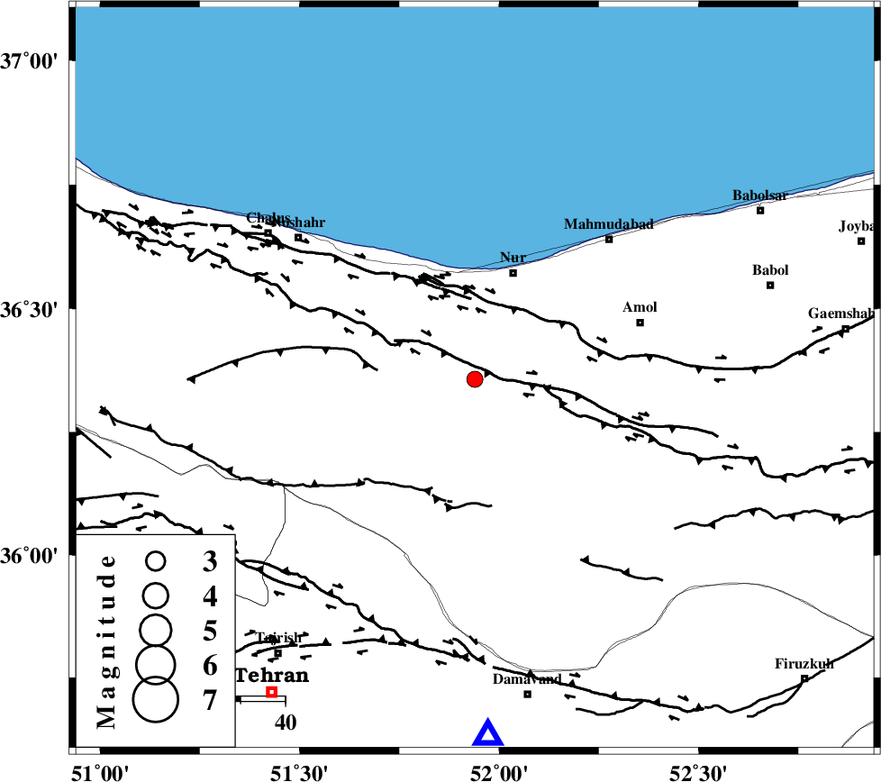
| Location | Lat:36.357 Lon: 51.939 |
| Region | Mazandaran Province, 25 km South of Nur |
Nearest Cities |
|
| 20 km East of Kujur, Mazandaran Province | |
| 20 km South of Narenj bon, Mazandaran Province | |
| 21 km South West of Chamestan, Mazandaran Province | |
| 21 km North of Pil, Mazandaran Province | |
| 21 km North East of Baladeh, Mazandaran Province | |
| Depth | 15 km |
| Agency | |
Faults within 150 km: |
|
| N_ALBORZ_F (Length: 360 km) , Distance to epicenter: 3 km | |
| KHAZAR_F (Length: 523 km) , Distance to epicenter: 19 km | |
| KOJOOR (Length: 75 km) , Distance to epicenter: 22 km | |
| Number of Phases | 7 |
| RMS | 0.3 |
| Number of Stations | 6 |
| Error in Latitude | >6.1 km |
| Error in Longitude | 6.1 km |
| Error in Depth | 8.2 km |
Download waveform in seisan format
to download seisan software Click here
to access information about IIEES stations Click here
Amplitude | ||||||||
| UID | Agency | Station | Component | Amplitude | Period | Arrival Time | Proccessing Time | Signal Clip |
| 100952 | IIEES | GHVR | N | 38.5 | 0.31 | 2015-09-15 14:56:15 | 2015-09-16 11:54:00 | n |
| 100953 | IIEES | GHVR | E | 42 | 0.31 | 2015-09-15 14:56:22 | 2015-09-16 11:54:00 | n |
| 100954 | IIEES | ASAO | N | 27 | 0.64 | 2015-09-15 14:56:26 | 2015-09-16 11:54:00 | n |
Phase | ||||||||||||
| Agency | Station | Component | Phase Type | Phase Quality | First Motion | Observed Arrival Time | Time Residual | Loc. Flag | Input Weight | Distance | Azimuth | |
| IIEES | DAMV | Z | Pg | E | 2015-09-15 14:55:21 | -0.03 | y | 80.7 | 178 | |||
| IIEES | CHTH | Z | Pg | E | 2015-09-15 14:55:23 | 0.41 | y | 88.5 | 236 | |||
| IIEES | THKV | Z | Pg | E | 2015-09-15 14:55:25 | -0.55 | y | 107 | 243 | |||
| IIEES | GHVR | Z | Pn | E | 2015-09-15 14:55:41 | -0.39 | y | 218 | 197 | |||
| IIEES | ASAO | Z | Pn | E | 2015-09-15 14:55:48 | 0.27 | y | 265 | 221 | |||
| IIEES | ASAO | E | Sg | E | 2015-09-15 14:56:22 | 0.17 | y | 265 | 221 | |||
| IIEES | MRVT | Z | Pn | E | 2015-09-15 14:56:04 | 0.16 | y | 397 | 67 | |||