
Magnitude |
:3.1 |
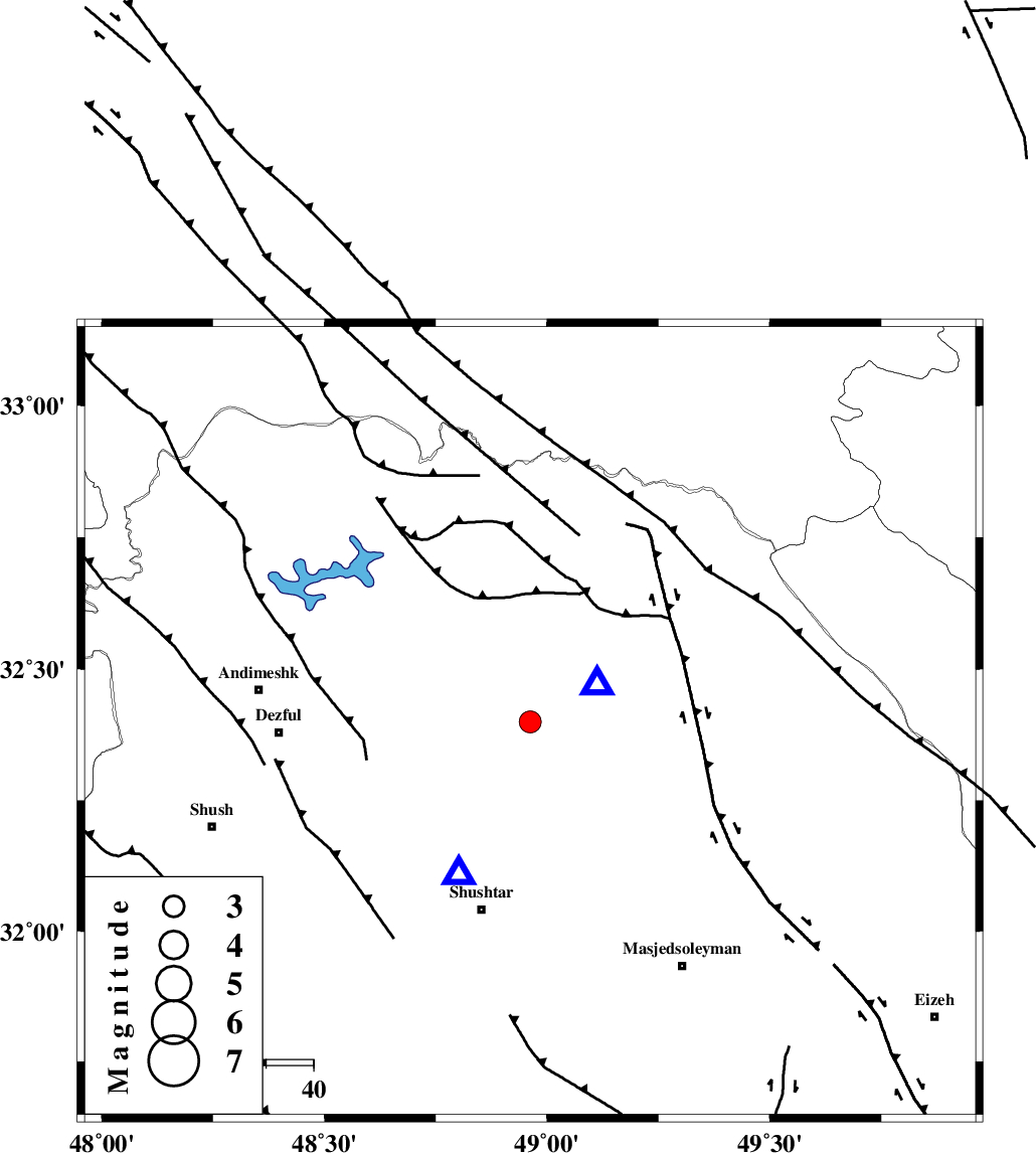
| Date & Time (UTC) | 2015-09-14 23:38:13.8 |
| Date & Time (Local) | 1394/6/24 04:08:13.8 |
| Location | Lat:32.399 Lon: 48.962 |
| Region | Khoozestan Province, 14 km -West of Lali |
Nearest Cities |
|
| 14 km North West of Lali, Khoozestan Province | |
| 16 km South East of Sardasht, Khoozestan Province | |
| 21 km North West of Jaefarabad, Khoozestan Province | |
| 22 km North East of Gatvand, Khoozestan Province | |
| 25 km North East of Samaleh, Khoozestan Province | |
| Depth | 37 km |
| Agency | |
Faults within 150 km: |
|
| DEZFUL_EMBAYMENT (Length: 228 km) , Distance to epicenter: 16 km | |
| MFF2 (Length: 205 km) , Distance to epicenter: 27 km | |
| BALARUD_F_Z2 (Length: 58 km) , Distance to epicenter: 33 km | |
| Number of Phases | 8 |
| RMS | 0.2 |
| Number of Stations | 5 |
| Error in Latitude | >3.9 km |
| Error in Longitude | 5.2 km |
| Error in Depth | 6.2 km |
Download waveform in seisan format
to download seisan software Click here
to access information about IIEES stations Click here
Amplitude | ||||||||
| UID | Agency | Station | Component | Amplitude | Period | Arrival Time | Proccessing Time | Signal Clip |
| 100934 | IIEES | ASAO | E | 126.9 | 0.35 | 2015-09-14 23:39:36 | 2015-09-15 09:30:00 | n |
| 100935 | IIEES | NASN | E | 30.7 | 0.47 | 2015-09-14 23:40:07 | 2015-09-15 09:30:00 | n |
Phase | ||||||||||||
| Agency | Station | Component | Phase Type | Phase Quality | First Motion | Observed Arrival Time | Time Residual | Loc. Flag | Input Weight | Distance | Azimuth | |
| IIEES | KHMZ | Z | Pg | E | 2015-09-14 23:38:42 | 0.04 | y | 176 | 32 | |||
| IIEES | ASAO | Z | Pn | E | 2015-09-14 23:38:51 | 0.17 | y | 258 | 22 | |||
| IIEES | ASAO | E | Sg | E | 2015-09-14 23:39:25 | -0.14 | y | 258 | 22 | |||
| IIEES | GHVR | Z | Pn | E | 2015-09-14 23:38:58 | -0.13 | y | 314 | 42 | |||
| IIEES | GHVR | E | Sg | E | 2015-09-14 23:39:40 | 0.1 | y | 314 | 42 | |||
| IIEES | NASN | Z | Pn | E | 2015-09-14 23:39:05 | 0.22 | y | 364 | 82 | |||
| IIEES | NASN | N | Sg | E | 2015-09-14 23:39:53 | 0.02 | y | 364 | 82 | |||
| IIEES | YZKH | Z | Pn | E | 2015-09-14 23:39:25 | -0.38 | y | 530 | 89 | |||