
Magnitude |
:2.4 |
| Date & Time (UTC) | 2015-09-14 08:19:18.4 |
| Date & Time (Local) | 1394/6/23 12:49:18.4 |
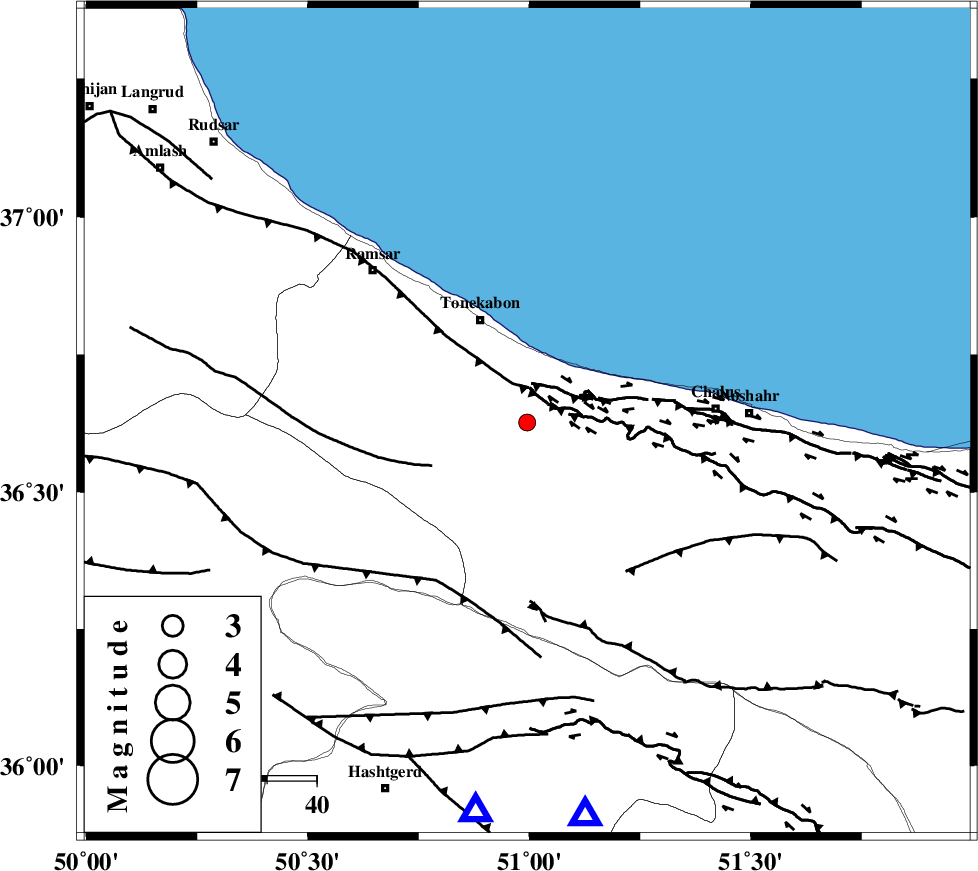
| Location | Lat:36.627 Lon: 50.995 |
| Region | Mazandaran Province, 23 km South-East of Tonekabon |
Nearest Cities |
|
| 11 km South of Kanza, Mazandaran Province | |
| 15 km West of Abbasabad, Mazandaran Province | |
| 20 km South East of Khorramabad, Mazandaran Province | |
| 20 km West of Tazehabad, Mazandaran Province | |
| 23 km South East of Tonekabon, Mazandaran Province | |
| Depth | 14 km |
| Agency | |
Faults within 150 km: |
|
| KHAZAR_F (Length: 523 km) , Distance to epicenter: 8 km | |
| N_ALBORZ_F (Length: 360 km) , Distance to epicenter: 8 km | |
| BONAN_F (Length: 74 km) , Distance to epicenter: 21 km | |
| Number of Phases | 7 |
| RMS | 0.2 |
| Number of Stations | 6 |
| Error in Latitude | >6.9 km |
| Error in Longitude | 5 km |
| Error in Depth | 5.2 km |
Download waveform in seisan format
to download seisan software Click here
to access information about IIEES stations Click here
Amplitude | ||||||||
| UID | Agency | Station | Component | Amplitude | Period | Arrival Time | Proccessing Time | Signal Clip |
| 100928 | IIEES | THKV | N | 197 | 0.22 | 2015-09-14 08:19:44 | 2015-09-15 09:30:00 | n |
| 100929 | IIEES | CHTH | E | 132.9 | 0.21 | 2015-09-14 08:19:45 | 2015-09-15 09:30:00 | n |
Phase | ||||||||||||
| Agency | Station | Component | Phase Type | Phase Quality | First Motion | Observed Arrival Time | Time Residual | Loc. Flag | Input Weight | Distance | Azimuth | |
| IIEES | THKV | Z | Pg | E | 2015-09-14 08:19:31 | -0.43 | y | 79.6 | 188 | |||
| IIEES | CHTH | Z | Pg | E | 2015-09-14 08:19:32 | 0.24 | y | 80.6 | 172 | |||
| IIEES | DAMV | Z | Pg | E | 2015-09-14 08:19:41 | -0.14 | y | 141 | 141 | |||
| IIEES | ZNJK | Z | Pn | E | 2015-09-14 08:19:51 | -0.09 | y | 207 | 272 | |||
| IIEES | ZNJK | N | Sg | E | 2015-09-14 08:20:17 | 0.03 | y | 207 | 272 | |||
| IIEES | GHVR | Z | Pn | E | 2015-09-14 08:19:56 | 0.23 | y | 239 | 174 | |||
| IIEES | ASAO | Z | Pn | E | 2015-09-14 08:19:57 | 0.17 | y | 247 | 201 | |||