
Magnitude |
:2 |
| Date & Time (UTC) | 2015-09-10 11:25:59.3 |
| Date & Time (Local) | 1394/6/19 15:55:59.3 |
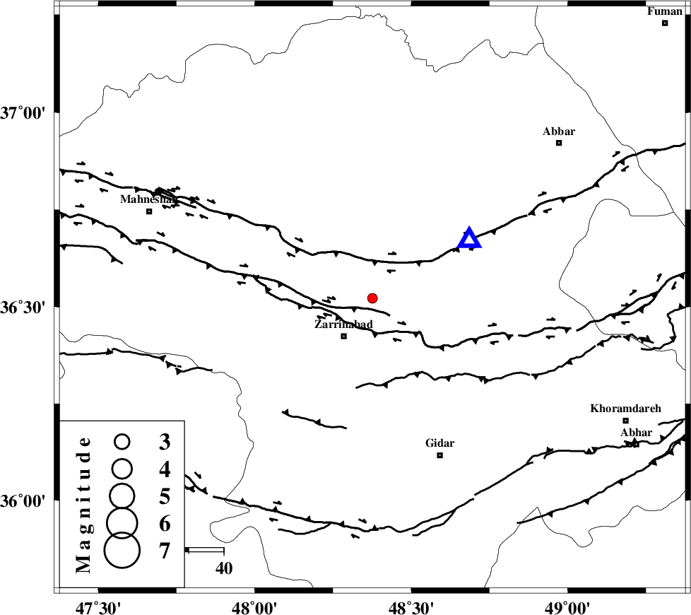
| Location | Lat:36.522 Lon: 48.376 |
| Region | Zanjan Province, 14 km of Zarrinabad |
Nearest Cities |
|
| 9 km of Ezhdehatu, Zanjan Province | |
| 14 km North of Zarrinabad, Zanjan Province | |
| 18 km North of Joqin, Zanjan Province | |
| 19 km South West of Zanjan, Zanjan Province | |
| 24 km North East of Qalatuq, Zanjan Province | |
| Depth | 6 km |
| Agency | |
Faults within 150 km: |
|
| SOLTANIYEH_F (Length: 119 km) , Distance to epicenter: 4 km | |
| ZANJAN_F (Length: 137 km) , Distance to epicenter: 22 km | |
| MASULEL_F (Length: 90 km) , Distance to epicenter: 73 km | |
| Number of Phases | 6 |
| RMS | 0.1 |
| Number of Stations | 5 |
| Error in Latitude | >3.3 km |
| Error in Longitude | 6.2 km |
| Error in Depth | 8.3 km |
Download waveform in seisan format
to download seisan software Click here
to access information about IIEES stations Click here
Amplitude | ||||||||
| UID | Agency | Station | Component | Amplitude | Period | Arrival Time | Proccessing Time | Signal Clip |
| 100901 | IIEES | ZNJK | N | 251.6 | 0.59 | 2015-09-10 11:26:16 | 2015-09-13 08:31:00 | n |
| 100902 | IIEES | ZNJK | E | 182.4 | 0.47 | 2015-09-10 11:26:17 | 2015-09-13 08:31:00 | n |
Phase | ||||||||||||
| Agency | Station | Component | Phase Type | Phase Quality | First Motion | Observed Arrival Time | Time Residual | Loc. Flag | Input Weight | Distance | Azimuth | |
| IIEES | ZNJK | Z | Pg | E | 2015-09-10 11:26:05 | -0.05 | y | 32.2 | 59 | |||
| IIEES | CHTH | Z | Pn | E | 2015-09-10 11:26:40 | 0.25 | y | 256 | 105 | |||
| IIEES | CHTH | E | Sg | E | 2015-09-10 11:27:15 | -0.07 | y | 256 | 105 | |||
| IIEES | GRMI | Z | Pn | E | 2015-09-10 11:26:39 | -0.04 | y | 257 | 351 | |||
| IIEES | ASAO | Z | Pn | E | 2015-09-10 11:26:41 | 0.09 | y | 265 | 145 | |||
| IIEES | KHMZ | Z | Pn | E | 2015-09-10 11:26:50 | -0.2 | y | 341 | 154 | |||