
Magnitude |
:2.1 |
| Date & Time (UTC) | 2015-09-10 03:20:39.6 |
| Date & Time (Local) | 1394/6/19 07:50:39.6 |
| Location | Lat:36.83 Lon: 58.408 |
| Region | Khorasan(center) Province, 32 km South of Quchan |
Nearest Cities |
|
| 6 km of Chakaneh, Khorasan(center) Province | |
| 16 km North of Abdollahgiv, Khorasan(center) Province | |
| 20 km South East of Yangi qaleh, Khorasan(center) Province | |
| 31 km South West of Ali Abad, Khorasan(center) Province | |
| 32 km South of Quchan, Khorasan(center) Province | |
| Depth | 18 km |
| Agency | |
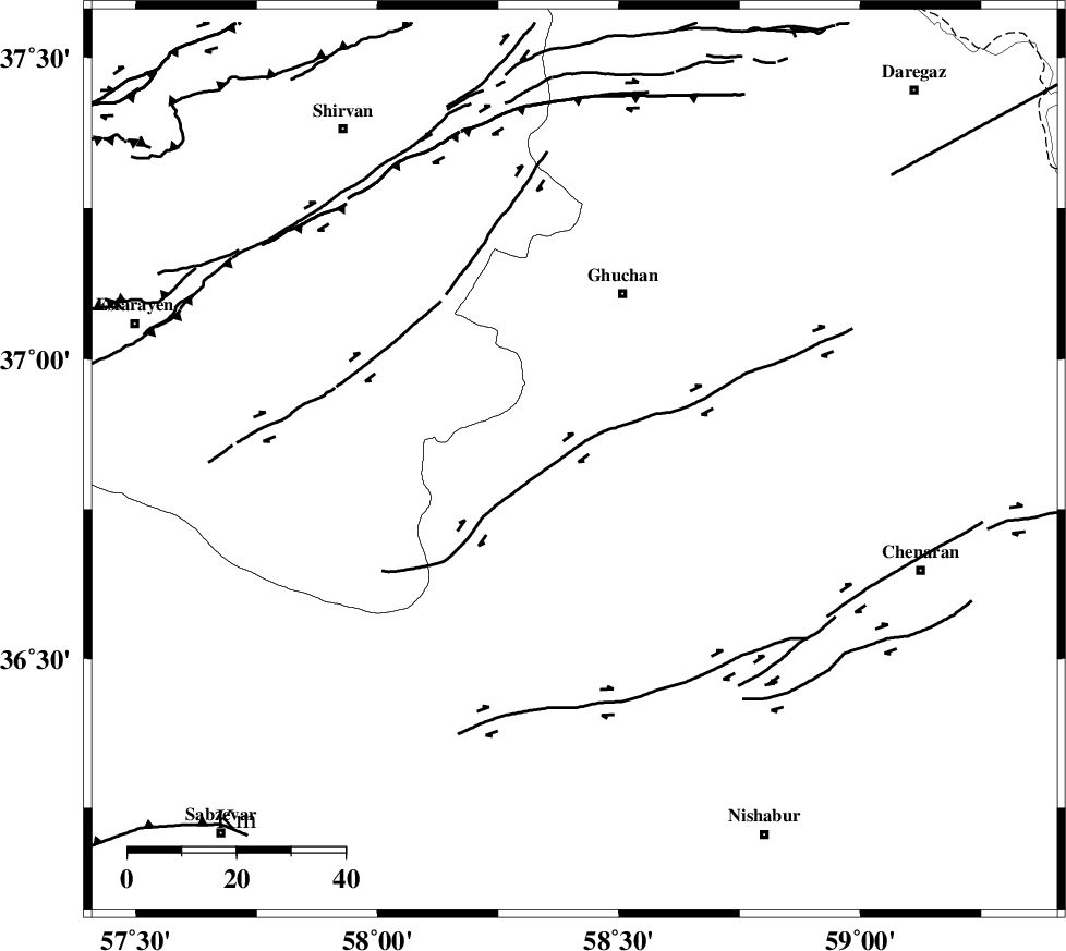
Faults within 150 km: |
|
| BINALUD_F1 (Length: 129 km) , Distance to epicenter: 11 km | |
| GHUCHAN_F (Length: 50 km) , Distance to epicenter: 30 km | |
| RIVAND_F (Length: 70 km) , Distance to epicenter: 33 km | |
| Number of Phases | 5 |
| RMS | 0.1 |
| Number of Stations | 3 |
| Error in Latitude | >2 km |
| Error in Longitude | 4.1 km |
| Error in Depth | 4.4 km |
Download waveform in seisan format
to download seisan software Click here
to access information about IIEES stations Click here
Amplitude | ||||||||
| UID | Agency | Station | Component | Amplitude | Period | Arrival Time | Proccessing Time | Signal Clip |
| 100894 | IIEES | BJRD | E | 37.4 | 0.16 | 2015-09-10 03:21:23 | 2015-09-13 08:31:00 | n |
Phase | ||||||||||||
| Agency | Station | Component | Phase Type | Phase Quality | First Motion | Observed Arrival Time | Time Residual | Loc. Flag | Input Weight | Distance | Azimuth | |
| IIEES | BJRD | Z | Pg | E | 2015-09-10 03:21:01 | 0.08 | y | 131 | 318 | |||
| IIEES | MRVT | Z | Pn | E | 2015-09-10 03:21:14 | -0.1 | y | 225 | 295 | |||
| IIEES | MRVT | E | Sg | E | 2015-09-10 03:21:43 | -0.02 | y | 225 | 295 | |||
| IIEES | SHRO | Z | Pn | E | 2015-09-10 03:21:16 | 0.02 | y | 233 | 248 | |||
| IIEES | SHRO | N | Sg | E | 2015-09-10 03:21:45 | 0.02 | y | 233 | 248 | |||