
Magnitude |
:1.9 |
| Date & Time (UTC) | 2015-09-07 17:38:49.8 |
| Date & Time (Local) | 1394/6/16 22:08:49.8 |
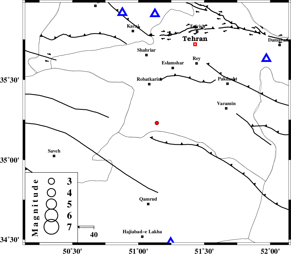
| Location | Lat:35.23 Lon: 51.14 |
| Region | Tehran Province, 28 km South of Robatkarim |
Nearest Cities |
|
| 24 km South of Vahnabad, Tehran Province | |
| 28 km South of Robatkarim, Tehran Province | |
| 35 km South of Manjilabad, Tehran Province | |
| 38 km South West of Kahrizak, Tehran Province | |
| 39 km South West of Deh abbas, Tehran Province | |
| Depth | 15 km |
| Agency | |
Faults within 150 km: |
|
| SIAHKUH_F (Length: 154 km) , Distance to epicenter: 10 km | |
| KAHRIZAK_F (Length: 44 km) , Distance to epicenter: 30 km | |
| S_PARANDAK_F (Length: 116 km) , Distance to epicenter: 33 km | |
| Number of Phases | 8 |
| RMS | 0.3 |
| Number of Stations | 6 |
| Error in Latitude | >2.1 km |
| Error in Longitude | 3.8 km |
| Error in Depth | 8.7 km |
Download waveform in seisan format
to download seisan software Click here
to access information about IIEES stations Click here
Amplitude | ||||||||
| UID | Agency | Station | Component | Amplitude | Period | Arrival Time | Proccessing Time | Signal Clip |
| 100805 | IIEES | CHTH | E | 47.3 | 0.13 | 2015-09-07 17:39:19 | 2015-09-08 09:19:00 | n |
| 100806 | IIEES | ASAO | N | 38 | 0.14 | 2015-09-07 17:39:27 | 2015-09-08 09:19:00 | n |
Phase | ||||||||||||
| Agency | Station | Component | Phase Type | Phase Quality | First Motion | Observed Arrival Time | Time Residual | Loc. Flag | Input Weight | Distance | Azimuth | |
| IIEES | CHTH | Z | Pg | E | 2015-09-07 17:39:02 | -0.06 | y | 75.2 | 359 | |||
| IIEES | THKV | Z | Pg | E | 2015-09-07 17:39:03 | -0.17 | y | 79.7 | 343 | |||
| IIEES | GHVR | Z | Pg | E | 2015-09-07 17:39:04 | 0.54 | y | 83.7 | 173 | |||
| IIEES | GHVR | E | Sg | E | 2015-09-07 17:39:14 | -0.4 | y | 83.7 | 173 | |||
| IIEES | DAMV | Z | Pg | E | 2015-09-07 17:39:05 | 0.21 | y | 87.5 | 59 | |||
| IIEES | ASAO | Z | Pg | E | 2015-09-07 17:39:11 | -0.12 | y | 127 | 234 | |||
| IIEES | ASAO | E | Sg | E | 2015-09-07 17:39:27 | 0.32 | y | 127 | 234 | |||
| IIEES | KHMZ | Z | Pn | E | 2015-09-07 17:39:21 | -0.32 | y | 197 | 213 | |||