
Magnitude |
:2.5 |
| Date & Time (UTC) | 2015-09-07 06:05:18.2 |
| Date & Time (Local) | 1394/6/16 10:35:18.2 |
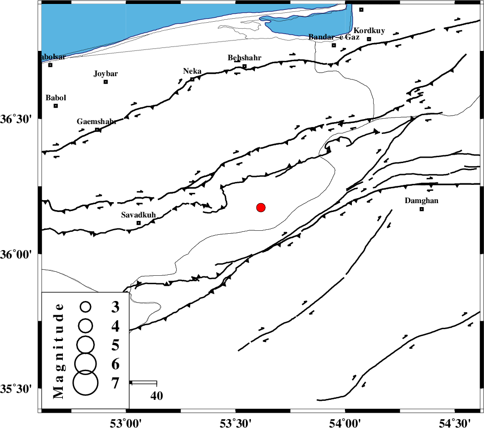
| Location | Lat:36.172 Lon: 53.615 |
| Region | Mazandaran Province, 58 km South of Behshahr |
Nearest Cities |
|
| 9 km of Talma darreh, Mazandaran Province | |
| 10 km of Kiasar, Mazandaran Province | |
| 30 km South East of Khalkhil, Mazandaran Province | |
| 33 km North West of Darvar, Semnan Province | |
| 37 km North East of Sangdeh, Mazandaran Province | |
| Depth | 14 km |
| Agency | |
Faults within 150 km: |
|
| DAMGHAN_F (Length: 95 km) , Distance to epicenter: 20 km | |
| N_ALBORZ_F (Length: 360 km) , Distance to epicenter: 24 km | |
| ASTANEH_F (Length: 72 km) , Distance to epicenter: 35 km | |
| Number of Phases | 6 |
| RMS | 0 |
| Number of Stations | 5 |
| Error in Latitude | >6 km |
| Error in Longitude | 1.3 km |
| Error in Depth | 3 km |
Download waveform in seisan format
to download seisan software Click here
to access information about IIEES stations Click here
Amplitude | ||||||||
| UID | Agency | Station | Component | Amplitude | Period | Arrival Time | Proccessing Time | Signal Clip |
| 100787 | IIEES | GHVR | N | 19.1 | 0.54 | 2015-09-07 06:06:48 | 2015-09-07 07:31:00 | n |
| 100788 | IIEES | GHVR | E | 22.9 | 0.31 | 2015-09-07 06:06:48 | 2015-09-07 07:31:00 | n |
Phase | ||||||||||||
| Agency | Station | Component | Phase Type | Phase Quality | First Motion | Observed Arrival Time | Time Residual | Loc. Flag | Input Weight | Distance | Azimuth | |
| IIEES | DAMV | Z | Pg | E | 2015-09-07 06:05:44 | -0.05 | y | 160 | 248 | |||
| IIEES | SHRO | Z | Pn | E | 2015-09-07 06:05:52 | 0.03 | y | 217 | 94 | |||
| IIEES | SHRO | E | Sg | E | 2015-09-07 06:06:19 | -0.03 | y | 217 | 94 | |||
| IIEES | CHTH | Z | Pn | E | 2015-09-07 06:05:54 | 0.02 | y | 226 | 263 | |||
| IIEES | GHVR | Z | Pn | E | 2015-09-07 06:06:01 | 0.07 | y | 286 | 230 | |||
| IIEES | ASAO | Z | Pn | E | 2015-09-07 06:06:12 | -0.04 | y | 373 | 242 | |||