
Magnitude |
:3.1 |
| Date & Time (UTC) | 2015-09-06 11:38:54.4 |
| Date & Time (Local) | 1394/6/15 16:08:54.4 |
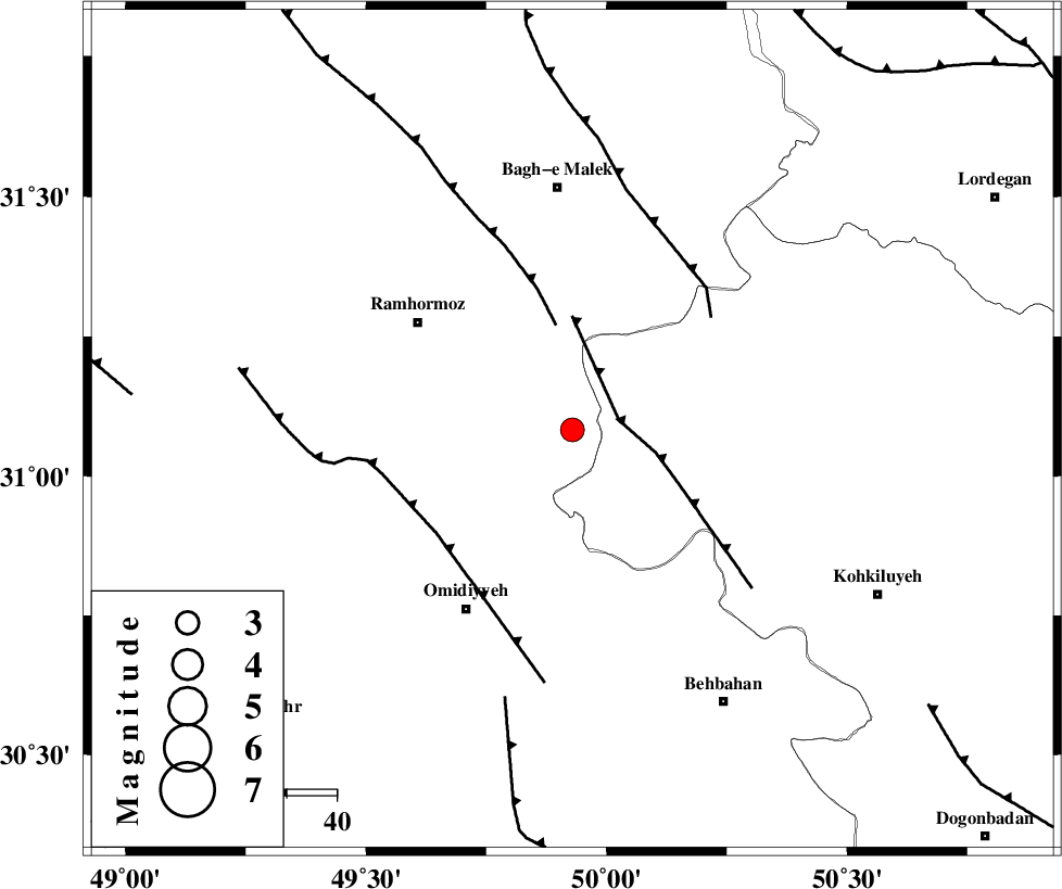
| Location | Lat:31.083 Lon: 49.929 |
| Region | Khoozestan Province, 48 km South of Bagh Malek |
Nearest Cities |
|
| 22 km North East of Soltanabad, Khoozestan Province | |
| 24 km North of Jayzan, Khoozestan Province | |
| 27 km South of Dalan, Khoozestan Province | |
| 30 km North of Jolaki, Khoozestan Province | |
| 34 km South West of Seidun, Khoozestan Province | |
| Depth | 16 km |
| Agency | |
Faults within 150 km: |
|
| MFF4 (Length: 62 km) , Distance to epicenter: 9 km | |
| DEZFUL_EMBAYMENT (Length: 228 km) , Distance to epicenter: 21 km | |
| AGHAJARI_F (Length: 88 km) , Distance to epicenter: 34 km | |
| Number of Phases | 8 |
| RMS | 0.2 |
| Number of Stations | 5 |
| Error in Latitude | >1.9 km |
| Error in Longitude | 8.3 km |
| Error in Depth | 5.5 km |
Download waveform in seisan format
to download seisan software Click here
to access information about IIEES stations Click here
Amplitude | ||||||||
| UID | Agency | Station | Component | Amplitude | Period | Arrival Time | Proccessing Time | Signal Clip |
| 100772 | IIEES | ASAO | E | 44.1 | 0.62 | 2015-09-06 11:40:47 | 2015-09-07 06:34:00 | n |
Phase | ||||||||||||
| Agency | Station | Component | Phase Type | Phase Quality | First Motion | Observed Arrival Time | Time Residual | Loc. Flag | Input Weight | Distance | Azimuth | |
| IIEES | AHRM | Z | Pn | E | 2015-09-06 11:39:36 | -0.1 | y | 279 | 151 | |||
| IIEES | AHRM | E | Sg | E | 2015-09-06 11:40:12 | 0.02 | y | 279 | 151 | |||
| IIEES | KHMZ | Z | Pn | E | 2015-09-06 11:39:38 | 0.2 | y | 295 | 1 | |||
| IIEES | NASN | Z | Pn | E | 2015-09-06 11:39:43 | 0.33 | y | 332 | 54 | |||
| IIEES | ASAO | Z | Pn | E | 2015-09-06 11:39:49 | -0.18 | y | 384 | 1 | |||
| IIEES | ASAO | E | Sg | E | 2015-09-06 11:40:42 | 0.25 | y | 384 | 1 | |||
| IIEES | GHVR | Z | Pn | E | 2015-09-06 11:39:50 | -0.3 | y | 396 | 18 | |||
| IIEES | GHVR | E | Sg | E | 2015-09-06 11:40:44 | -0.29 | y | 396 | 18 | |||