
Magnitude |
:2.9 |
| Date & Time (UTC) | 2015-09-03 07:09:43.1 |
| Date & Time (Local) | 1394/6/12 11:39:43.1 |
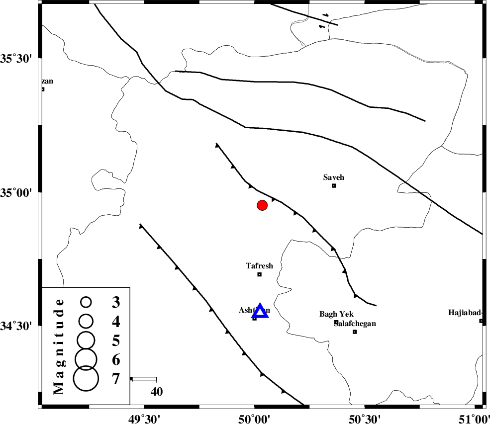
| Location | Lat:34.951 Lon: 50.035 |
| Region | Markazi Province, 29 km North of Tafresh |
Nearest Cities |
|
| 11 km North of Khanak, Markazi Province | |
| 12 km South of Qeytaniyeh, Markazi Province | |
| 21 km North East of Bazarjan, Markazi Province | |
| 25 km North West of Yalabad, Markazi Province | |
| 26 km South East of Gharqabad, Markazi Province | |
| Depth | 15 km |
| Agency | |
Faults within 150 km: |
|
| INDES_F (Length: 98 km) , Distance to epicenter: 6 km | |
| KUSHK_E_NOSRAT_F (Length: 230 km) , Distance to epicenter: 32 km | |
| TAFRESH_F (Length: 117 km) , Distance to epicenter: 44 km | |
| Number of Phases | 7 |
| RMS | 0.4 |
| Number of Stations | 5 |
| Error in Latitude | >2.7 km |
| Error in Longitude | 5.1 km |
| Error in Depth | 7.8 km |
Download waveform in seisan format
to download seisan software Click here
to access information about IIEES stations Click here
Amplitude | ||||||||
| UID | Agency | Station | Component | Amplitude | Period | Arrival Time | Proccessing Time | Signal Clip |
| 100761 | IIEES | ASAO | E | 661.9 | 0.13 | 2015-09-03 07:09:56 | 2015-09-06 09:05:00 | n |
| 100762 | IIEES | ASAO | N | 1260.8 | 0.16 | 2015-09-03 07:09:56 | 2015-09-06 09:05:00 | n |
| 100763 | IIEES | CHTH | E | 243.6 | 0.28 | 2015-09-03 07:10:29 | 2015-09-06 09:05:00 | n |
Phase | ||||||||||||
| Agency | Station | Component | Phase Type | Phase Quality | First Motion | Observed Arrival Time | Time Residual | Loc. Flag | Input Weight | Distance | Azimuth | |
| IIEES | ASAO | Z | Pg | E | 2015-09-03 07:09:50 | -0.65 | y | 44.7 | 181 | |||
| IIEES | GHVR | Z | Pg | E | 2015-09-03 07:10:03 | -0.15 | y | 123 | 115 | |||
| IIEES | GHVR | N | Sg | E | 2015-09-03 07:10:19 | 0.4 | y | 123 | 115 | |||
| IIEES | CHTH | Z | Pg | E | 2015-09-03 07:10:07 | -0.03 | y | 145 | 43 | |||
| IIEES | CHTH | E | Sg | E | 2015-09-03 07:10:24 | -0.42 | y | 145 | 43 | |||
| IIEES | ZNJK | Z | Pn | E | 2015-09-03 07:10:19 | 0.49 | y | 226 | 328 | |||
| IIEES | NASN | Z | Pn | E | 2015-09-03 07:10:34 | 0.42 | y | 350 | 132 | |||