
Magnitude |
:2.6 |
| Date & Time (UTC) | 2015-09-05 00:20:29.9 |
| Date & Time (Local) | 1394/6/14 04:50:29.9 |
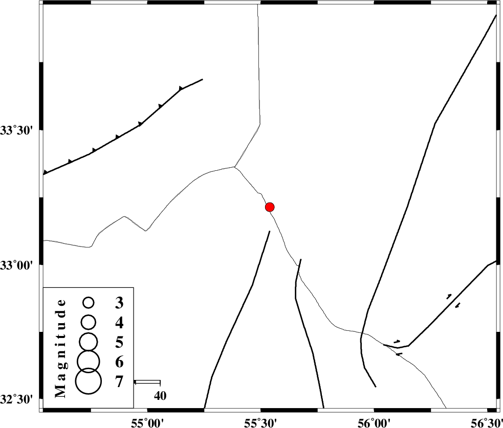
| Location | Lat:33.214 Lon: 55.539 |
| Region | Yazd Province, 180 km North-East of Bafq |
Nearest Cities |
|
| 22 km North of Robat-e posht-e badam, Yazd Province | |
| 48 km South East of Mehranjan, Esfahan Province | |
| 59 km North East of Hajiabad, Yazd Province | |
| 69 km South West of Darin, Yazd Province | |
| 76 km South East of Khur, Esfahan Province | |
| Depth | 15 km |
| Agency | |
Faults within 150 km: |
|
| POSHT_E_BADAM_F (Length: 128 km) , Distance to epicenter: 10 km | |
| SARBALA_F (Length: 92 km) , Distance to epicenter: 25 km | |
| NAINI_F (Length: 342 km) , Distance to epicenter: 54 km | |
| Number of Phases | 6 |
| RMS | 0.3 |
| Number of Stations | 4 |
| Error in Latitude | >7.5 km |
| Error in Longitude | 3.2 km |
| Error in Depth | 7.3 km |
Download waveform in seisan format
to download seisan software Click here
to access information about IIEES stations Click here
Amplitude | ||||||||
| UID | Agency | Station | Component | Amplitude | Period | Arrival Time | Proccessing Time | Signal Clip |
| 100696 | IIEES | BSRN | E | 14.1 | 0.39 | 2015-09-05 00:22:19 | 2015-09-05 08:07:00 | n |
| 100697 | IIEES | BSRN | N | 12.8 | 0.15 | 2015-09-05 00:22:20 | 2015-09-05 08:07:00 | n |
Phase | ||||||||||||
| Agency | Station | Component | Phase Type | Phase Quality | First Motion | Observed Arrival Time | Time Residual | Loc. Flag | Input Weight | Distance | Azimuth | |
| IIEES | YZKH | Z | Pg | E | 2015-09-05 00:20:51 | 0.19 | y | 127 | 224 | |||
| IIEES | TABS | Z | Pg | E | 2015-09-05 00:20:55 | 0.38 | y | 155 | 71 | |||
| IIEES | TABS | N | Sg | E | 2015-09-05 00:21:14 | -0.23 | y | 155 | 71 | |||
| IIEES | NASN | Z | Pn | E | 2015-09-05 00:21:10 | 0.29 | y | 259 | 261 | |||
| IIEES | NASN | N | Sg | E | 2015-09-05 00:21:43 | -0.35 | y | 259 | 261 | |||
| IIEES | BSRN | Z | Pn | E | 2015-09-05 00:21:22 | -0.34 | y | 364 | 111 | |||