
Magnitude |
:1.5 |
| Date & Time (UTC) | 2015-09-03 21:45:27.3 |
| Date & Time (Local) | 1394/6/13 02:15:27.3 |
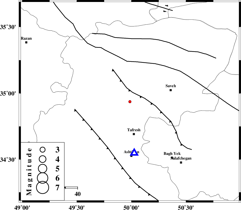
| Location | Lat:34.937 Lon: 49.986 |
| Region | Markazi Province, 27 km North of Tafresh |
Nearest Cities |
|
| 12 km North of Khanak, Markazi Province | |
| 14 km South of Qeytaniyeh, Markazi Province | |
| 18 km North of Bazarjan, Markazi Province | |
| 24 km South East of Gharqabad, Markazi Province | |
| 24 km North East of Jaghtan, Markazi Province | |
| Depth | 18 km |
| Agency | |
Faults within 150 km: |
|
| INDES_F (Length: 98 km) , Distance to epicenter: 8 km | |
| KUSHK_E_NOSRAT_F (Length: 230 km) , Distance to epicenter: 34 km | |
| TAFRESH_F (Length: 117 km) , Distance to epicenter: 39 km | |
| Number of Phases | 5 |
| RMS | 0.2 |
| Number of Stations | 4 |
| Error in Latitude | >2.4 km |
| Error in Longitude | 3.3 km |
| Error in Depth | 9.6 km |
Download waveform in seisan format
to download seisan software Click here
to access information about IIEES stations Click here
Amplitude | ||||||||
| UID | Agency | Station | Component | Amplitude | Period | Arrival Time | Proccessing Time | Signal Clip |
| 100676 | IIEES | ASAO | E | 27 | 0.11 | 2015-09-03 21:45:41 | 2015-09-05 06:26:00 | n |
| 100677 | IIEES | ASAO | N | 64.8 | 0.17 | 2015-09-03 21:45:41 | 2015-09-05 06:26:00 | n |
Phase | ||||||||||||
| Agency | Station | Component | Phase Type | Phase Quality | First Motion | Observed Arrival Time | Time Residual | Loc. Flag | Input Weight | Distance | Azimuth | |
| IIEES | ASAO | Z | Pg | E | 2015-09-03 21:45:35 | -0.17 | y | 43.2 | 175 | |||
| IIEES | GHVR | Z | P | E | 2015-09-03 21:45:47 | -0.21 | y | 126 | 113 | |||
| IIEES | GHVR | E | Sg | E | 2015-09-03 21:46:04 | 0.1 | y | 126 | 113 | |||
| IIEES | KHMZ | Z | Pg | E | 2015-09-03 21:45:49 | 0.22 | y | 133 | 181 | |||
| IIEES | CHTH | Z | Pg | E | 2015-09-03 21:45:52 | 0.06 | y | 149 | 44 | |||