
Magnitude |
:3 |
| Date & Time (UTC) | 2015-09-01 05:02:23.5 |
| Date & Time (Local) | 1394/6/10 09:32:23.5 |
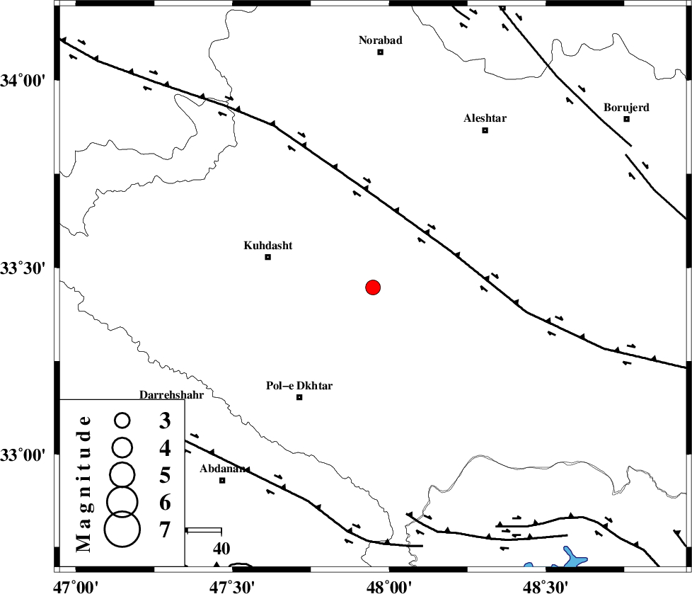
| Location | Lat:33.447 Lon: 47.948 |
| Region | Lorestan Province, 32 km -East of Kuhdasht |
Nearest Cities |
|
| 9 km North of Maeulan, Lorestan Province | |
| 9 km of Mahmudvand, Lorestan Province | |
| 15 km South of Sarabboreh, Lorestan Province | |
| 18 km West of Godar-e mahmudvand, Lorestan Province | |
| 24 km North West of Shoorab-e sofla, Lorestan Province | |
| Depth | 14 km |
| Agency | |
Faults within 150 km: |
|
| HZF4 (Length: 492 km) , Distance to epicenter: 25 km | |
| BALARUD_F_Z1 (Length: 87 km) , Distance to epicenter: 67 km | |
| BALARUD_F_Z3 (Length: 53 km) , Distance to epicenter: 68 km | |
| Number of Phases | 8 |
| RMS | 0.4 |
| Number of Stations | 6 |
| Error in Latitude | >7.6 km |
| Error in Longitude | 5.9 km |
| Error in Depth | 8.8 km |
Download waveform in seisan format
to download seisan software Click here
to access information about IIEES stations Click here
Amplitude | ||||||||
| UID | Agency | Station | Component | Amplitude | Period | Arrival Time | Proccessing Time | Signal Clip |
| 100656 | IIEES | ZNJK | E | 34.5 | 0.76 | 2015-09-01 05:04:16 | 2015-09-01 11:30:00 | n |
Phase | ||||||||||||
| Agency | Station | Component | Phase Type | Phase Quality | First Motion | Observed Arrival Time | Time Residual | Loc. Flag | Input Weight | Distance | Azimuth | |
| IIEES | KHMZ | Z | Pg | E | 2015-09-01 05:02:54 | -0.24 | y | 190 | 80 | |||
| IIEES | SNGE | Z | Pg | E | 2015-09-01 05:02:54 | -0.74 | y | 191 | 343 | |||
| IIEES | SNGE | N | Sg | E | 2015-09-01 05:03:18 | 0.37 | y | 191 | 343 | |||
| IIEES | ASAO | Z | Pn | E | 2015-09-01 05:03:00 | 0.41 | y | 227 | 57 | |||
| IIEES | ASAO | N | Sg | E | 2015-09-01 05:03:27 | -0.2 | y | 227 | 57 | |||
| IIEES | GHVR | Z | Pn | E | 2015-09-01 05:03:12 | 0.4 | y | 326 | 68 | |||
| IIEES | ZNJK | Z | Pn | E | 2015-09-01 05:03:16 | 0.15 | y | 364 | 10 | |||
| IIEES | CHTH | Z | Pn | E | 2015-09-01 05:03:20 | -0.1 | y | 399 | 46 | |||