
Magnitude |
:2.3 |
| Date & Time (UTC) | 2015-08-31 16:27:38.3 |
| Date & Time (Local) | 1394/6/9 20:57:38.3 |
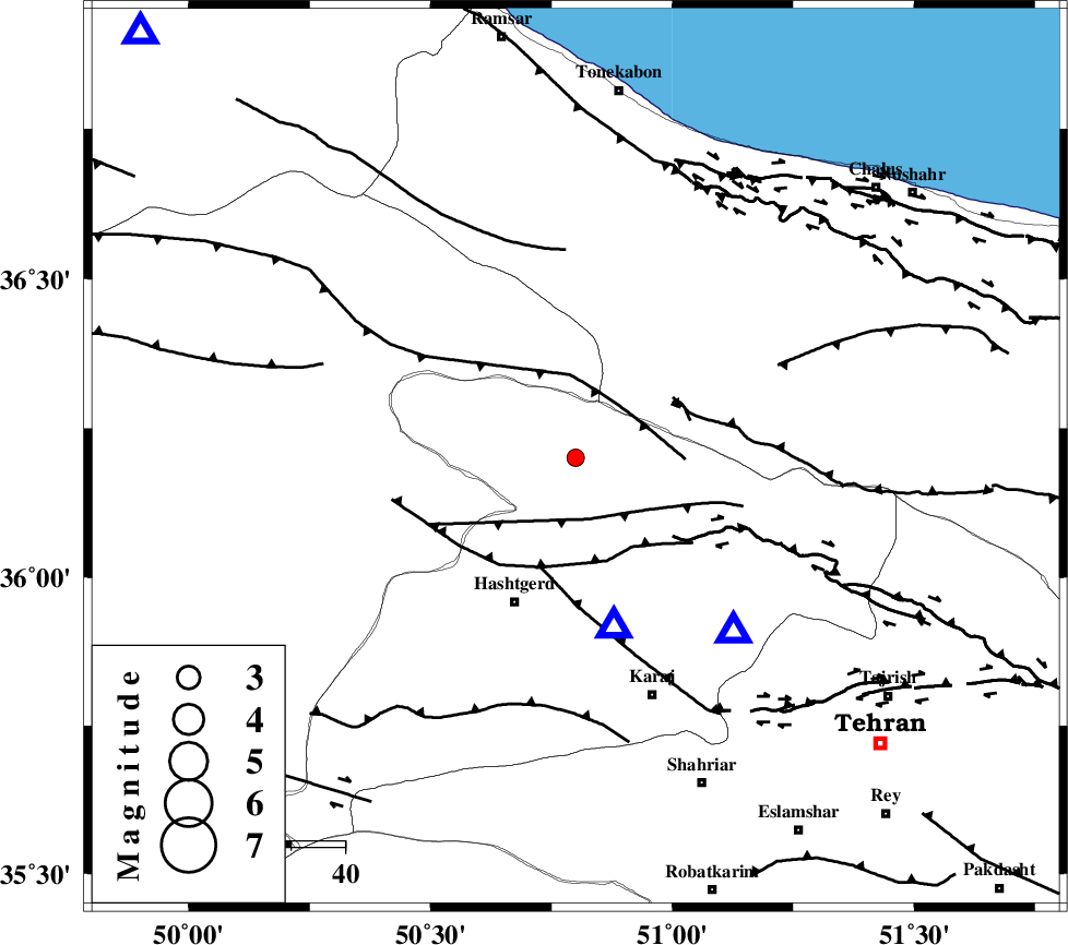
| Location | Lat:36.2 Lon: 50.8 |
| Region | Tehran Province, 29 km North-East of Hashtgerd |
Nearest Cities |
|
| 4 km North of Shahrak, Tehran Province | |
| 12 km North East of Taleqan, Tehran Province | |
| 28 km North of Chandar, Tehran Province | |
| 29 km North East of Hashtgerd, Tehran Province | |
| 30 km North East of Abyek, Ghazvin Province | |
| Depth | 6 km |
| Agency | |
Faults within 150 km: |
|
| TALEGHAN_F (Length: 71 km) , Distance to epicenter: 12 km | |
| ALAMUTRUD_F (Length: 140 km) , Distance to epicenter: 13 km | |
| MOSHA_F (Length: 234 km) , Distance to epicenter: 20 km | |
| Number of Phases | 8 |
| RMS | 0.1 |
| Number of Stations | 6 |
| Error in Latitude | >2.1 km |
| Error in Longitude | 2.2 km |
| Error in Depth | 4.9 km |
Download waveform in seisan format
to download seisan software Click here
to access information about IIEES stations Click here
Amplitude | ||||||||
| UID | Agency | Station | Component | Amplitude | Period | Arrival Time | Proccessing Time | Signal Clip |
| 100653 | IIEES | GHVR | N | 34.5 | 0.26 | 2015-08-31 16:28:37 | 2015-09-01 06:56:00 | n |
| 100654 | IIEES | GHVR | E | 32 | 0.24 | 2015-08-31 16:28:41 | 2015-09-01 06:56:00 | n |
| 100655 | IIEES | ASAO | N | 20.7 | 0.4 | 2015-08-31 16:28:38 | 2015-09-01 06:56:00 | n |
Phase | ||||||||||||
| Agency | Station | Component | Phase Type | Phase Quality | First Motion | Observed Arrival Time | Time Residual | Loc. Flag | Input Weight | Distance | Azimuth | |
| IIEES | CHTH | Z | Pg | E | 2015-08-31 16:27:46 | -0.12 | y | 43.7 | 138 | |||
| IIEES | CHTH | E | Sg | E | 2015-08-31 16:27:52 | 0.03 | y | 43.7 | 138 | |||
| IIEES | DAMV | Z | Pg | E | 2015-08-31 16:27:59 | 0.1 | y | 123 | 121 | |||
| IIEES | GHVR | Z | Pg | E | 2015-08-31 16:28:11 | -0.14 | y | 195 | 168 | |||
| IIEES | GHVR | N | Sg | E | 2015-08-31 16:28:36 | 0.05 | y | 195 | 168 | |||
| IIEES | ASAO | Z | Pg | E | 2015-08-31 16:28:12 | -0.08 | y | 196 | 201 | |||
| IIEES | ZNJK | Z | Pg | E | 2015-08-31 16:28:12 | -0.14 | y | 197 | 286 | |||
| IIEES | SNGE | Z | Pn | E | 2015-08-31 16:28:29 | 0.33 | y | 336 | 250 | |||