
Magnitude |
:1.8 |
| Date & Time (UTC) | 2015-08-31 13:05:22.3 |
| Date & Time (Local) | 1394/6/9 17:35:22.3 |
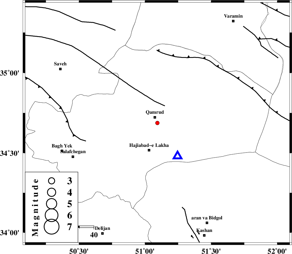
| Location | Lat:34.687 Lon: 51.093 |
| Region | Qom Province, 21 km -East of Qom |
Nearest Cities |
|
| 4 km of Qamrud, Qom Province | |
| 20 km North of Hajiabad-e lakha, Qom Province | |
| 21 km North East of Qom, Qom Province | |
| 40 km North East of Kahak, Qom Province | |
| 51 km North of Yahyaabad, Esfahan Province | |
| Depth | 14 km |
| Agency | |
Faults within 150 km: |
|
| KUSHK_E_NOSRAT_F (Length: 230 km) , Distance to epicenter: 13 km | |
| SIAHKUH_F (Length: 154 km) , Distance to epicenter: 48 km | |
| INDES_F (Length: 98 km) , Distance to epicenter: 51 km | |
| Number of Phases | 6 |
| RMS | 0.4 |
| Number of Stations | 6 |
| Error in Latitude | >2.9 km |
| Error in Longitude | 6.3 km |
| Error in Depth | 7.2 km |
Download waveform in seisan format
to download seisan software Click here
to access information about IIEES stations Click here
Amplitude | ||||||||
| UID | Agency | Station | Component | Amplitude | Period | Arrival Time | Proccessing Time | Signal Clip |
| 100641 | IIEES | GHVR | N | 161.8 | 0.43 | 2015-08-31 13:05:36 | 2015-09-01 06:56:00 | n |
Phase | ||||||||||||
| Agency | Station | Component | Phase Type | Phase Quality | First Motion | Observed Arrival Time | Time Residual | Loc. Flag | Input Weight | Distance | Azimuth | |
| IIEES | GHVR | Z | Pg | E | 2015-08-31 13:05:27 | -0.03 | y | 26.8 | 149 | |||
| IIEES | DAMV | Z | Pg | E | 2015-08-31 13:05:45 | 0.19 | y | 132 | 37 | |||
| IIEES | CHTH | Z | Pg | E | 2015-08-31 13:05:45 | -0.69 | y | 136 | 1 | |||
| IIEES | THKV | Z | Pg | E | 2015-08-31 13:05:46 | 0.53 | y | 138 | 352 | |||
| IIEES | KHMZ | Z | Pg | E | 2015-08-31 13:05:48 | 0.01 | y | 148 | 225 | |||
| IIEES | NASN | Z | Pn | E | 2015-08-31 13:06:03 | -0.01 | y | 263 | 142 | |||