
Magnitude |
:2.9 |
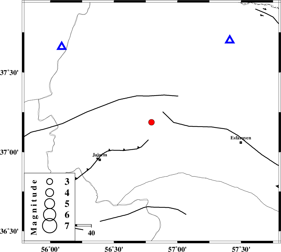
| Date & Time (UTC) | 2015-08-31 02:20:48.1 |
| Date & Time (Local) | 1394/6/9 06:50:48.1 |
| Location | Lat:37.187 Lon: 56.795 |
| Region | Khorasan(north) Province, 42 km South-West of Ashkhaneh |
Nearest Cities |
|
| 18 km South of Shogan, Khorasan(north) Province | |
| 36 km North West of Cheharborj, Khorasan(north) Province | |
| 42 km South West of Ashkhaneh, Khorasan(north) Province | |
| 43 km North of Farashiyan, Khorasan(center) Province | |
| 45 km North East of Jajarm, Khorasan(north) Province | |
| Depth | 16 km |
| Agency | |
Faults within 150 km: |
|
| ESFARAYEN_F (Length: 111 km) , Distance to epicenter: 11 km | |
| JAJARAM_F (Length: 77 km) , Distance to epicenter: 13 km | |
| ROBATE_QARABIL_F (Length: 168 km) , Distance to epicenter: 19 km | |
| Number of Phases | 6 |
| RMS | 0 |
| Number of Stations | 4 |
| Error in Latitude | >1.2 km |
| Error in Longitude | 1.1 km |
| Error in Depth | 4.4 km |
Download waveform in seisan format
to download seisan software Click here
to access information about IIEES stations Click here
Amplitude | ||||||||
| UID | Agency | Station | Component | Amplitude | Period | Arrival Time | Proccessing Time | Signal Clip |
| 100632 | IIEES | BJRD | E | 523.9 | 0.31 | 2015-08-31 02:21:14 | 2015-08-31 05:47:00 | n |
Phase | ||||||||||||
| Agency | Station | Component | Phase Type | Phase Quality | First Motion | Observed Arrival Time | Time Residual | Loc. Flag | Input Weight | Distance | Azimuth | |
| IIEES | BJRD | Z | Pg | E | 2015-08-31 02:21:01 | 0.03 | y | 78.6 | 43 | |||
| IIEES | BJRD | E | Sg | E | 2015-08-31 02:21:11 | -0.02 | y | 78.6 | 43 | |||
| IIEES | MRVT | Z | Pg | E | 2015-08-31 02:21:02 | 0 | y | 81.6 | 310 | |||
| IIEES | MRVT | N | Sg | E | 2015-08-31 02:21:12 | 0 | y | 81.6 | 310 | |||
| IIEES | SHRO | Z | Pg | E | 2015-08-31 02:21:12 | -0.01 | y | 148 | 208 | |||
| IIEES | SHRT | Z | Pn | E | 2015-08-31 02:21:58 | 0 | y | 505 | 140 | |||