
Magnitude |
:3.5 |
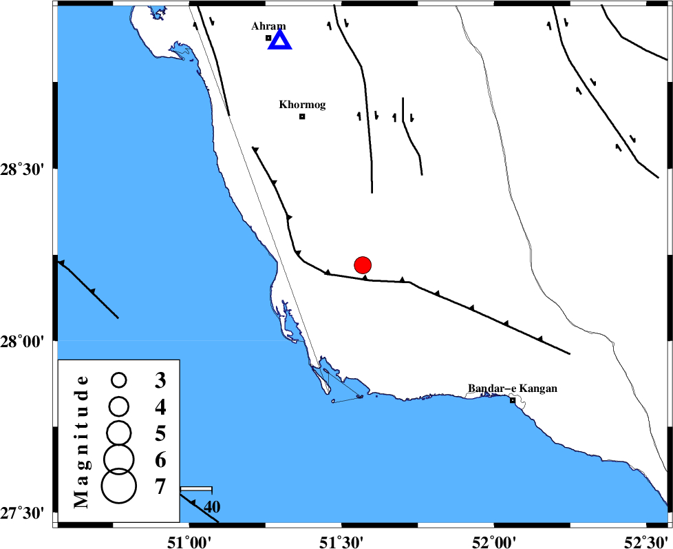
| Date & Time (UTC) | 2015-08-27 00:01:11.7 |
| Date & Time (Local) | 1394/6/5 04:31:11.7 |
| Location | Lat:28.22 Lon: 51.569 |
| Region | Bushehr Province, 52 km South-East of Khormog |
Nearest Cities |
|
| 7 km North of Abkesh, Bushehr Province | |
| 14 km South of Kaki, Bushehr Province | |
| 20 km North of Bardkhun, Bushehr Province | |
| 21 km North East of Ziyarat, Bushehr Province | |
| 21 km South of Baduleh, Bushehr Province | |
| Depth | 14 km |
| Agency | |
Faults within 150 km: |
|
| BORAZJAN_F (Length: 168 km) , Distance to epicenter: 6 km | |
| MFF3 (Length: 292 km) , Distance to epicenter: 8 km | |
| ZFF2 (Length: 84 km) , Distance to epicenter: 19 km | |
| Number of Phases | 5 |
| RMS | 0.1 |
| Number of Stations | 4 |
| Error in Latitude | >5.9 km |
| Error in Longitude | 9.1 km |
| Error in Depth | 7.6 km |
Download waveform in seisan format
to download seisan software Click here
to access information about IIEES stations Click here
Amplitude | ||||||||
| UID | Agency | Station | Component | Amplitude | Period | Arrival Time | Proccessing Time | Signal Clip |
| 100615 | IIEES | AHRM | E | 2102 | 0.62 | 2015-08-27 00:01:41 | 2015-08-30 11:02:00 | n |
| 100616 | IIEES | AHRM | N | 2020.9 | 0.79 | 2015-08-27 00:01:43 | 2015-08-30 11:02:00 | n |
Phase | ||||||||||||
| Agency | Station | Component | Phase Type | Phase Quality | First Motion | Observed Arrival Time | Time Residual | Loc. Flag | Input Weight | Distance | Azimuth | |
| IIEES | AHRM | Z | Pg | E | 2015-08-27 00:01:24 | 0.01 | y | 76.3 | 340 | |||
| IIEES | AHRM | N | Sg | E | 2015-08-27 00:01:34 | -0.01 | y | 76.3 | 340 | |||
| IIEES | NASN | Z | Pn | E | 2015-08-27 00:02:24 | 0.19 | y | 521 | 13 | |||
| IIEES | YZKH | Z | Pn | E | 2015-08-27 00:02:27 | -0.13 | y | 546 | 31 | |||
| IIEES | KHMZ | Z | Pn | E | 2015-08-27 00:02:37 | -0.08 | y | 631 | 346 | |||