
Magnitude |
:2.9 |
| Date & Time (UTC) | 2015-08-26 13:38:43.0 |
| Date & Time (Local) | 1394/6/4 18:08:43.0 |
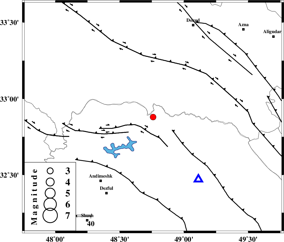
| Location | Lat:32.88 Lon: 48.76 |
| Region | Khoozestan Province, 60 km North-East of Andimeshk |
Nearest Cities |
|
| 10 km North of Shuy, Khoozestan Province | |
| 25 km South West of Bargsar, Lorestan Province | |
| 34 km South of Chamsangar, Lorestan Province | |
| 42 km North East of Sorkhakan, Khoozestan Province | |
| 43 km North of Sardasht, Khoozestan Province | |
| Depth | 15 km |
| Agency | |
Faults within 150 km: |
|
| BALARUD_F_Z2 (Length: 58 km) , Distance to epicenter: 11 km | |
| MFF2 (Length: 205 km) , Distance to epicenter: 17 km | |
| BALARUD_F_Z3 (Length: 53 km) , Distance to epicenter: 21 km | |
| Number of Phases | 4 |
| RMS | 0.5 |
| Number of Stations | 4 |
| Error in Latitude | >6.2 km |
| Error in Longitude | 5.3 km |
| Error in Depth | 0 km |
Download waveform in seisan format
to download seisan software Click here
to access information about IIEES stations Click here
Amplitude | ||||||||
| UID | Agency | Station | Component | Amplitude | Period | Arrival Time | Proccessing Time | Signal Clip |
| 100601 | IIEES | SNGE | N | 50.6 | 0.37 | 2015-08-26 13:40:08 | 2015-08-30 11:02:00 | n |
| 100602 | IIEES | GHVR | N | 36.3 | 0.56 | 2015-08-26 13:40:15 | 2015-08-30 11:02:00 | n |
| 100603 | IIEES | GHVR | E | 39.1 | 0.28 | 2015-08-26 13:40:17 | 2015-08-30 11:02:00 | n |
| 100604 | IIEES | AHRM | N | 20.8 | 0.35 | 2015-08-26 13:40:41 | 2015-08-30 11:02:00 | n |
Phase | ||||||||||||
| Agency | Station | Component | Phase Type | Phase Quality | First Motion | Observed Arrival Time | Time Residual | Loc. Flag | Input Weight | Distance | Azimuth | |
| IIEES | SNGE | Z | Pn | E | 2015-08-26 13:39:24 | -0.41 | y | 278 | 332 | |||
| IIEES | GHVR | Z | Pn | E | 2015-08-26 13:39:26 | -0.29 | y | 291 | 52 | |||
| IIEES | ZNJK | Z | Pn | E | 2015-08-26 13:39:43 | 0.77 | y | 421 | 359 | |||
| IIEES | AHRM | Z | Pn | E | 2015-08-26 13:39:53 | 0.12 | y | 507 | 151 | |||