
Magnitude |
:2.6 |
| Date & Time (UTC) | 2015-08-27 05:27:36.8 |
| Date & Time (Local) | 1394/6/5 09:57:36.8 |
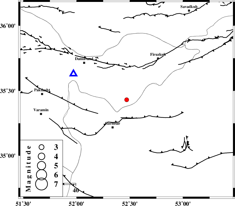
| Location | Lat:35.431 Lon: 52.471 |
| Region | Tehran Province, 27 km North-East of Garmsar |
Nearest Cities |
|
| 21 km South West of Atashan, Tehran Province | |
| 21 km North of Aradan, Semnan Province | |
| 24 km North of Davarabad, Semnan Province | |
| 24 km North of Kohanabad, Semnan Province | |
| 27 km North East of Garmsar, Semnan Province | |
| Depth | 18 km |
| Agency | |
Faults within 150 km: |
|
| GARMSAR_F (Length: 77 km) , Distance to epicenter: 17 km | |
| EYVANEKEY_F (Length: 74 km) , Distance to epicenter: 27 km | |
| MOSHA_F (Length: 234 km) , Distance to epicenter: 30 km | |
| Number of Phases | 6 |
| RMS | 0.1 |
| Number of Stations | 5 |
| Error in Latitude | >2.7 km |
| Error in Longitude | 2.8 km |
| Error in Depth | 7.5 km |
Download waveform in seisan format
to download seisan software Click here
to access information about IIEES stations Click here
Amplitude | ||||||||
| UID | Agency | Station | Component | Amplitude | Period | Arrival Time | Proccessing Time | Signal Clip |
| 100563 | IIEES | NASN | N | 24.6 | 0.22 | 2015-08-27 05:28:57 | 2015-08-29 11:24:00 | n |
Phase | ||||||||||||
| Agency | Station | Component | Phase Type | Phase Quality | First Motion | Observed Arrival Time | Time Residual | Loc. Flag | Input Weight | Distance | Azimuth | |
| IIEES | CHTH | Z | Pg | E | 2015-08-27 05:27:59 | 0.1 | y | 133 | 294 | |||
| IIEES | CHTH | E | Sg | E | 2015-08-27 05:28:15 | -0.09 | y | 133 | 294 | |||
| IIEES | NASN | Z | Pn | E | 2015-08-27 05:28:20 | -0.06 | y | 294 | 174 | |||
| IIEES | KHMZ | Z | Pn | E | 2015-08-27 05:28:21 | 0.05 | y | 297 | 232 | |||
| IIEES | SHRO | Z | P | E | 2015-08-27 05:28:24 | 0 | y | 327 | 78 | |||
| IIEES | MRVT | Z | P | E | 2015-08-27 05:28:34 | -0.01 | y | 408 | 52 | |||