
Magnitude |
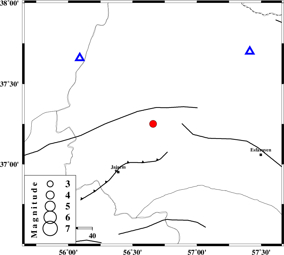
:3.5 |
| Date & Time (UTC) | 2015-08-27 20:45:17.1 |
| Date & Time (Local) | 1394/6/6 01:15:17.1 |
| Location | Lat:37.251 Lon: 56.659 |
| Region | Khorasan(north) Province, 41 km North-East of Jajarm |
Nearest Cities |
|
| 19 km West of Shogan, Khorasan(north) Province | |
| 41 km North East of Jajarm, Khorasan(north) Province | |
| 41 km South West of Ashkhaneh, Khorasan(north) Province | |
| 44 km North East of Garmeh, Khorasan(north) Province | |
| 49 km North West of Cheharborj, Khorasan(north) Province | |
| Depth | 15 km |
| Agency | |
Faults within 150 km: |
|
| ROBATE_QARABIL_F (Length: 168 km) , Distance to epicenter: 12 km | |
| ESFARAYEN_F (Length: 111 km) , Distance to epicenter: 20 km | |
| JAJARAM_F (Length: 77 km) , Distance to epicenter: 22 km | |
| Number of Phases | 10 |
| RMS | 0.3 |
| Number of Stations | 9 |
| Error in Latitude | >2.8 km |
| Error in Longitude | 3.4 km |
| Error in Depth | 5.9 km |
Download waveform in seisan format
to download seisan software Click here
to access information about IIEES stations Click here
Amplitude | ||||||||
| UID | Agency | Station | Component | Amplitude | Period | Arrival Time | Proccessing Time | Signal Clip |
| 100557 | IIEES | BJRD | E | 1777.1 | 0.22 | 2015-08-27 20:45:44 | 2015-08-29 09:10:00 | n |
Phase | ||||||||||||
| Agency | Station | Component | Phase Type | Phase Quality | First Motion | Observed Arrival Time | Time Residual | Loc. Flag | Input Weight | Distance | Azimuth | |
| IIEES | MRVT | Z | Pg | E | 2015-08-27 20:45:29 | 0.08 | y | 67.8 | 312 | |||
| IIEES | MRVT | E | Sg | E | 2015-08-27 20:45:37 | -0.19 | y | 67.8 | 312 | |||
| IIEES | BJRD | Z | Pg | E | 2015-08-27 20:45:31 | 0.17 | y | 82.9 | 53 | |||
| IIEES | SHRO | Z | Pg | E | 2015-08-27 20:45:41 | -0.17 | y | 149 | 203 | |||
| IIEES | TABS | Z | Pn | E | 2015-08-27 20:46:15 | 0.46 | y | 402 | 174 | |||
| IIEES | SHRT | Z | Pn | E | 2015-08-27 20:46:28 | -0.74 | y | 518 | 139 | |||
| IIEES | YZKH | Z | Pn | E | 2015-08-27 20:46:36 | 0.28 | y | 571 | 200 | |||
| IIEES | NASN | Z | Pn | E | 2015-08-27 20:46:40 | 0.07 | y | 606 | 217 | |||
| IIEES | BSRN | Z | Pn | E | 2015-08-27 20:46:42 | -0.18 | y | 628 | 158 | |||
| IIEES | ZNJK | Z | Pn | E | 2015-08-27 20:46:53 | 0.26 | y | 713 | 267 | |||