
Magnitude |
:2.4 |
| Date & Time (UTC) | 2015-08-29 01:46:33.7 |
| Date & Time (Local) | 1394/6/7 06:16:33.7 |
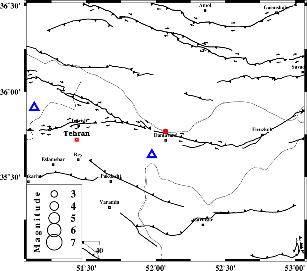
| Location | Lat:35.768 Lon: 52.069 |
| Region | Mazandaran Province, 6 km of Damavand |
Nearest Cities |
|
| 6 km North of Abali, Tehran Province | |
| 6 km North of Damavand, Tehran Province | |
| 14 km North of Ab sard, Tehran Province | |
| 16 km South of Rineh, Mazandaran Province | |
| 18 km North East of Rudehen, Tehran Province | |
| Depth | 14 km |
| Agency | |
Faults within 150 km: |
|
| MOSHA_F (Length: 234 km) , Distance to epicenter: 2 km | |
| N_TEHRAN_F4 (Length: 115 km) , Distance to epicenter: 26 km | |
| EYVANEKEY_F (Length: 74 km) , Distance to epicenter: 41 km | |
| Number of Phases | 6 |
| RMS | 0.3 |
| Number of Stations | 4 |
| Error in Latitude | >3.1 km |
| Error in Longitude | 4.2 km |
| Error in Depth | 6.6 km |
Download waveform in seisan format
to download seisan software Click here
to access information about IIEES stations Click here
Amplitude | ||||||||
| UID | Agency | Station | Component | Amplitude | Period | Arrival Time | Proccessing Time | Signal Clip |
| 100527 | IIEES | GHVR | N | 51.6 | 0.38 | 2015-08-29 01:47:27 | 2015-08-29 06:28:00 | n |
Phase | ||||||||||||
| Agency | Station | Component | Phase Type | Phase Quality | First Motion | Observed Arrival Time | Time Residual | Loc. Flag | Input Weight | Distance | Azimuth | |
| IIEES | DAMV | Z | Pg | E | 2015-08-29 01:46:37 | -0.07 | y | 17.7 | 210 | |||
| IIEES | CHTH | Z | Pg | E | 2015-08-29 01:46:49 | 0.4 | y | 86.6 | 281 | |||
| IIEES | CHTH | E | Sg | E | 2015-08-29 01:46:59 | -0.3 | y | 86.6 | 281 | |||
| IIEES | GHVR | Z | Pg | E | 2015-08-29 01:47:01 | 0.38 | y | 161 | 208 | |||
| IIEES | GHVR | N | Sg | E | 2015-08-29 01:47:21 | -0.22 | y | 161 | 208 | |||
| IIEES | SHRO | Z | Pn | E | 2015-08-29 01:47:25 | -0.23 | y | 357 | 85 | |||