
Magnitude |
:3.5 |
| Date & Time (UTC) | 2015-08-28 22:20:58.3 |
| Date & Time (Local) | 1394/6/7 02:50:58.3 |
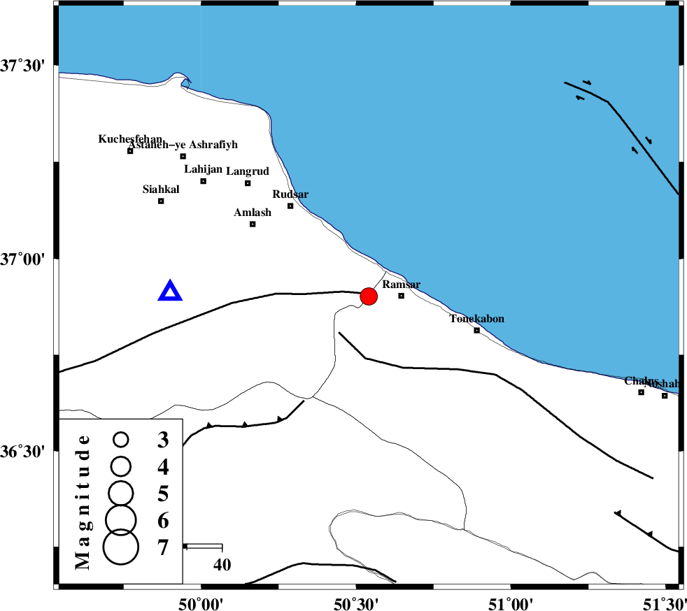
| Location | Lat:36.902 Lon: 50.541 |
| Region | Mazandaran Province, 9 km -West of Ramsar |
Nearest Cities |
|
| 8 km of Chaboksar, Gilan Province | |
| 8 km of Galesh mahalleh, Mazandaran Province | |
| 9 km West of Ramsar, Mazandaran Province | |
| 19 km South East of Vajargah, Gilan Province | |
| 23 km South East of Rahimabad, Gilan Province | |
| Depth | 17 km |
| Agency | |
Faults within 150 km: |
|
| KHAZAR_F (Length: 523 km) , Distance to epicenter: 7 km | |
| BONAN_F (Length: 74 km) , Distance to epicenter: 28 km | |
| LAHIJAN_F (Length: 92 km) , Distance to epicenter: 29 km | |
| Number of Phases | 7 |
| RMS | 0.4 |
| Number of Stations | 6 |
| Error in Latitude | >5.7 km |
| Error in Longitude | 6.4 km |
| Error in Depth | 9.8 km |
Download waveform in seisan format
to download seisan software Click here
to access information about IIEES stations Click here
Amplitude | ||||||||
| UID | Agency | Station | Component | Amplitude | Period | Arrival Time | Proccessing Time | Signal Clip |
| 100522 | IIEES | CHTH | E | 1385.9 | 0.2 | 2015-08-28 22:21:33 | 2015-08-29 06:28:00 | n |
| 100523 | IIEES | ZNJK | N | 524.1 | 0.37 | 2015-08-28 22:21:51 | 2015-08-29 06:28:00 | n |
| 100524 | IIEES | ZNJK | E | 435.1 | 0.12 | 2015-08-28 22:21:51 | 2015-08-29 06:28:00 | n |
| 100525 | IIEES | SHRO | N | 41.5 | 0.44 | 2015-08-28 22:23:28 | 2015-08-29 06:28:00 | n |
| 100526 | IIEES | SHRO | E | 49.5 | 0.71 | 2015-08-28 22:23:30 | 2015-08-29 06:28:00 | n |
Phase | ||||||||||||
| Agency | Station | Component | Phase Type | Phase Quality | First Motion | Observed Arrival Time | Time Residual | Loc. Flag | Input Weight | Distance | Azimuth | |
| IIEES | CHTH | Z | Pg | E | 2015-08-28 22:21:18 | -0.1 | y | 122 | 154 | |||
| IIEES | ZNJK | Z | Pg | E | 2015-08-28 22:21:26 | 0.44 | y | 168 | 262 | |||
| IIEES | DAMV | Z | Pg | E | 2015-08-28 22:21:29 | -0.02 | y | 191 | 137 | |||
| IIEES | GHVR | Z | Pn | E | 2015-08-28 22:21:40 | 0.31 | y | 276 | 166 | |||
| IIEES | GHVR | N | Sg | E | 2015-08-28 22:22:15 | -0.34 | y | 276 | 166 | |||
| IIEES | GRMI | Z | Pn | E | 2015-08-28 22:21:44 | -0.66 | y | 315 | 313 | |||
| IIEES | SHRO | Z | Pn | E | 2015-08-28 22:22:08 | 0.44 | y | 500 | 100 | |||