
Magnitude |
:2.6 |
| Date & Time (UTC) | 2015-08-23 07:13:36.7 |
| Date & Time (Local) | 1394/6/1 11:43:36.7 |
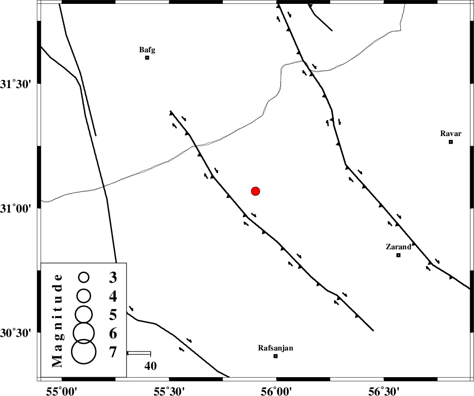
| Location | Lat:31.068 Lon: 55.902 |
| Region | Kerman Province, 74 km North of Rafsanjan |
Nearest Cities |
|
| 10 km North of Seyriz, Kerman Province | |
| 27 km North East of Bahreman, Kerman Province | |
| 28 km North of Ferdosiyeh, Kerman Province | |
| 28 km North East of Esmaeelabad, Kerman Province | |
| 46 km South of Basab, Yazd Province | |
| Depth | 14 km |
| Agency | |
Faults within 150 km: |
|
| DARIVAN_F (Length: 131 km) , Distance to epicenter: 12 km | |
| KUHBANAN_F (Length: 189 km) , Distance to epicenter: 42 km | |
| ANAR_F (Length: 127 km) , Distance to epicenter: 66 km | |
| Number of Phases | 6 |
| RMS | 0.3 |
| Number of Stations | 4 |
| Error in Latitude | >5.9 km |
| Error in Longitude | 7.9 km |
| Error in Depth | 9.4 km |
Download waveform in seisan format
to download seisan software Click here
to access information about IIEES stations Click here
Amplitude | ||||||||
| UID | Agency | Station | Component | Amplitude | Period | Arrival Time | Proccessing Time | Signal Clip |
| 100449 | IIEES | BSRN | N | 18.9 | 0.39 | 2015-08-23 07:15:10 | 2015-08-24 07:07:00 | n |
| 100450 | IIEES | BSRN | E | 22.1 | 0.31 | 2015-08-23 07:15:10 | 2015-08-24 07:07:00 | n |
Phase | ||||||||||||
| Agency | Station | Component | Phase Type | Phase Quality | First Motion | Observed Arrival Time | Time Residual | Loc. Flag | Input Weight | Distance | Azimuth | |
| IIEES | KRBR | Z | Pg | E | 2015-08-23 07:14:01 | 0.03 | y | 146 | 145 | |||
| IIEES | KRBR | E | Sg | E | 2015-08-23 07:14:18 | -0.09 | y | 146 | 145 | |||
| IIEES | YZKH | Z | Pg | E | 2015-08-23 07:14:07 | -0.63 | y | 192 | 320 | |||
| IIEES | YZKH | N | Sg | E | 2015-08-23 07:14:31 | 0.11 | y | 192 | 320 | |||
| IIEES | BSRN | Z | Pn | E | 2015-08-23 07:14:24 | 0.13 | y | 322 | 71 | |||
| IIEES | NASN | Z | Pn | E | 2015-08-23 07:14:28 | 0.54 | y | 350 | 304 | |||