
Magnitude |
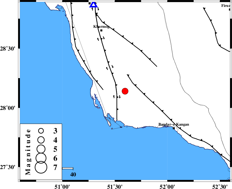
:3.8 |
| Date & Time (UTC) | 2015-08-24 02:45:26.9 |
| Date & Time (Local) | 1394/6/2 07:15:26.9 |
| Location | Lat:28.14 Lon: 51.597 |
| Region | Bushehr Province, 61 km South-East of Khormog |
Nearest Cities |
|
| 8 km of Abkesh, Bushehr Province | |
| 15 km North East of Bardkhun, Bushehr Province | |
| 17 km North West of Abdan, Bushehr Province | |
| 23 km East of Ziyarat, Bushehr Province | |
| 23 km South of Kaki, Bushehr Province | |
| Depth | 18 km |
| Agency | |
Faults within 150 km: |
|
| BORAZJAN_F (Length: 168 km) , Distance to epicenter: 8 km | |
| MFF3 (Length: 292 km) , Distance to epicenter: 11 km | |
| ZFF2 (Length: 84 km) , Distance to epicenter: 20 km | |
| Number of Phases | 6 |
| RMS | 0.1 |
| Number of Stations | 5 |
| Error in Latitude | >5.2 km |
| Error in Longitude | 6 km |
| Error in Depth | 5.8 km |
Download waveform in seisan format
to download seisan software Click here
to access information about IIEES stations Click here
Amplitude | ||||||||
| UID | Agency | Station | Component | Amplitude | Period | Arrival Time | Proccessing Time | Signal Clip |
| 100440 | IIEES | AHRM | E | 2811.8 | 0.5 | 2015-08-24 02:46:09 | 2015-08-24 06:42:00 | n |
| 100441 | IIEES | KRBR | N | 81.2 | 0.73 | 2015-08-24 02:47:50 | 2015-08-24 06:42:00 | n |
Phase | ||||||||||||
| Agency | Station | Component | Phase Type | Phase Quality | First Motion | Observed Arrival Time | Time Residual | Loc. Flag | Input Weight | Distance | Azimuth | |
| IIEES | AHRM | Z | Pg | E | 2015-08-24 02:45:41 | -0.05 | y | 85.6 | 340 | |||
| IIEES | AHRM | N | Sg | E | 2015-08-24 02:45:52 | 0.05 | y | 85.6 | 340 | |||
| IIEES | NASN | Z | Pn | E | 2015-08-24 02:46:40 | -0.17 | y | 529 | 12 | |||
| IIEES | KRBR | Z | Pn | E | 2015-08-24 02:46:41 | 0.1 | y | 543 | 67 | |||
| IIEES | YZKH | Z | Pn | E | 2015-08-24 02:46:43 | 0.01 | y | 552 | 31 | |||
| IIEES | SNGE | Z | Pn | E | 2015-08-24 02:47:22 | 0.16 | y | 870 | 333 | |||