
Magnitude |
:2.7 |
| Date & Time (UTC) | 2015-08-19 23:38:59.3 |
| Date & Time (Local) | 1394/5/29 04:08:59.3 |
| Location | Lat:37.47 Lon: 48.366 |
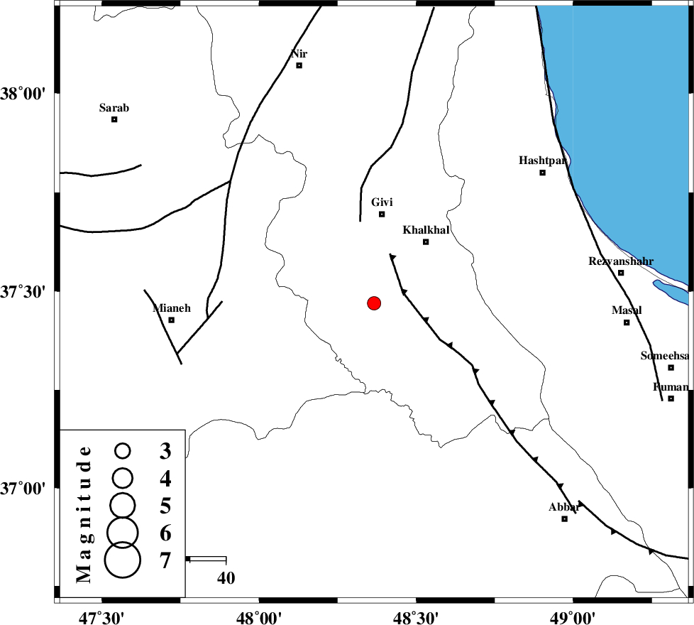
| Region | Ardebil Province, 25 km South of Givi |
Nearest Cities |
|
| 11 km South of Gazaz, Ardebil Province | |
| 12 km North of Hashtjin, Ardebil Province | |
| 18 km South East of Firuz Abad, Ardebil Province | |
| 22 km South West of Khojin, Ardebil Province | |
| 23 km South West of Khalkhal, Ardebil Province | |
| Depth | 14 km |
| Agency | |
Faults within 150 km: |
|
| MASULEL_F (Length: 90 km) , Distance to epicenter: 9 km | |
| SANGAVAR_F (Length: 61 km) , Distance to epicenter: 23 km | |
| BOZQUSH (Length: 70 km) , Distance to epicenter: 43 km | |
| Number of Phases | 7 |
| RMS | 0.2 |
| Number of Stations | 5 |
| Error in Latitude | >1.8 km |
| Error in Longitude | 5.4 km |
| Error in Depth | 4.5 km |
Download waveform in seisan format
to download seisan software Click here
to access information about IIEES stations Click here
Amplitude | ||||||||
| UID | Agency | Station | Component | Amplitude | Period | Arrival Time | Proccessing Time | Signal Clip |
| 100415 | IIEES | GRMI | E | 128.8 | 0.28 | 2015-08-19 23:39:46 | 2015-08-22 08:14:00 | n |
Phase | ||||||||||||
| Agency | Station | Component | Phase Type | Phase Quality | First Motion | Observed Arrival Time | Time Residual | Loc. Flag | Input Weight | Distance | Azimuth | |
| IIEES | ZNJK | Z | Pg | E | 2015-08-19 23:39:15 | 0.02 | y | 93.1 | 162 | |||
| IIEES | ZNJK | E | Sg | E | 2015-08-19 23:39:27 | -0.07 | y | 93.1 | 162 | |||
| IIEES | GRMI | Z | Pg | E | 2015-08-19 23:39:24 | -0.14 | y | 154 | 345 | |||
| IIEES | GRMI | N | Sg | E | 2015-08-19 23:39:43 | -0.1 | y | 154 | 345 | |||
| IIEES | SNGE | Z | Pn | E | 2015-08-19 23:39:41 | -0.2 | y | 279 | 199 | |||
| IIEES | CHTH | Z | Pn | E | 2015-08-19 23:39:44 | 0.17 | y | 301 | 124 | |||
| IIEES | MAKU | Z | Pn | E | 2015-08-19 23:39:55 | 0.4 | y | 384 | 304 | |||