
Magnitude |
:3.3 |
| Date & Time (UTC) | 2015-08-18 19:42:49.6 |
| Date & Time (Local) | 1394/5/28 00:12:49.6 |
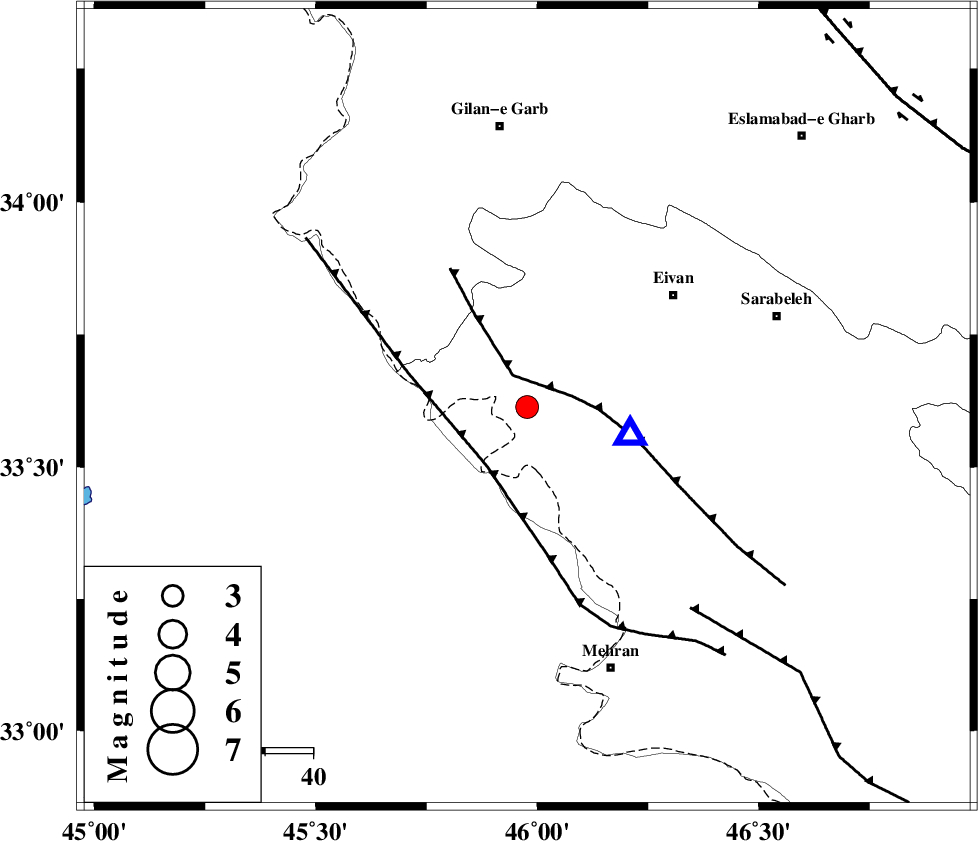
| Location | Lat:33.613 Lon: 45.977 |
| Region | Ilam Province, 42 km -West of Ilam |
Nearest Cities |
|
| 25 km North West of Salehabad, Ilam Province | |
| 28 km West of Chavar, Ilam Province | |
| 39 km South West of Eyvan, Ilam Province | |
| 40 km South West of Zarneh, Ilam Province | |
| 41 km South West of Teran, Ilam Province | |
| Depth | 15 km |
| Agency | |
Faults within 150 km: |
|
| MFF7 (Length: 99 km) , Distance to epicenter: 5 km | |
| ZFF4 (Length: 128 km) , Distance to epicenter: 15 km | |
| MFF6 (Length: 144 km) , Distance to epicenter: 54 km | |
| Number of Phases | 7 |
| RMS | 0.2 |
| Number of Stations | 5 |
| Error in Latitude | >5.8 km |
| Error in Longitude | 6.3 km |
| Error in Depth | 8.2 km |
Download waveform in seisan format
to download seisan software Click here
to access information about IIEES stations Click here
Amplitude | ||||||||
| UID | Agency | Station | Component | Amplitude | Period | Arrival Time | Proccessing Time | Signal Clip |
| 100404 | IIEES | SNGE | N | 241.8 | 0.7 | 2015-08-18 19:43:56 | 2015-08-19 07:43:00 | n |
Phase | ||||||||||||
| Agency | Station | Component | Phase Type | Phase Quality | First Motion | Observed Arrival Time | Time Residual | Loc. Flag | Input Weight | Distance | Azimuth | |
| IIEES | SNGE | Z | Pn | E | 2015-08-18 19:43:22 | -0.34 | y | 207 | 37 | |||
| IIEES | SNGE | N | Sg | E | 2015-08-18 19:43:48 | 0 | y | 207 | 37 | |||
| IIEES | KHMZ | Z | Pn | E | 2015-08-18 19:43:43 | 0.01 | y | 370 | 87 | |||
| IIEES | ZNJK | Z | Pn | E | 2015-08-18 19:43:49 | 0.34 | y | 419 | 35 | |||
| IIEES | GHVR | Z | Pn | E | 2015-08-18 19:43:58 | -0.09 | y | 496 | 77 | |||
| IIEES | GHVR | N | Sn | 2015-08-18 19:44:49 | -0.02 | y | 496 | 77 | ||||
| IIEES | CHTH | Z | Pn | E | 2015-08-18 19:44:04 | 0.23 | y | 536 | 60 | |||