
Magnitude |
:2.7 |
| Date & Time (UTC) | 2015-08-17 13:48:36.3 |
| Date & Time (Local) | 1394/5/26 18:18:36.3 |
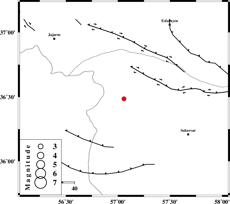
| Location | Lat:36.485 Lon: 57.058 |
| Region | Khorasan(center) Province, 63 km North-West of Sabzevar |
Nearest Cities |
|
| 16 km South of Abuchenari, Khorasan(center) Province | |
| 16 km South of Jogtay, Khorasan(center) Province | |
| 20 km South of Dasturan, Khorasan(center) Province | |
| 20 km North of Sadkharu, Khorasan(center) Province | |
| 22 km North East of Davarzan, Khorasan(center) Province | |
| Depth | 6 km |
| Agency | |
Faults within 150 km: |
|
| JOGHATAI_F (Length: 70 km) , Distance to epicenter: 13 km | |
| SABZEVAR_F (Length: 81 km) , Distance to epicenter: 15 km | |
| JAJARAM_F (Length: 77 km) , Distance to epicenter: 68 km | |
| Number of Phases | 7 |
| RMS | 0.2 |
| Number of Stations | 5 |
| Error in Latitude | >1.8 km |
| Error in Longitude | 3.6 km |
| Error in Depth | 7.1 km |
Download waveform in seisan format
to download seisan software Click here
to access information about IIEES stations Click here
Amplitude | ||||||||
| UID | Agency | Station | Component | Amplitude | Period | Arrival Time | Proccessing Time | Signal Clip |
| 100375 | IIEES | SHRO | N | 61.3 | 0.23 | 2015-08-17 13:49:14 | 2015-08-18 09:42:00 | n |
| 100376 | IIEES | MRVT | E | 170.7 | 0.29 | 2015-08-17 13:49:25 | 2015-08-18 09:42:00 | n |
| 100377 | IIEES | MRVT | N | 193.4 | 0.22 | 2015-08-17 13:49:26 | 2015-08-18 09:42:00 | n |
| 100378 | IIEES | TABS | E | 33.8 | 0.59 | 2015-08-17 13:50:27 | 2015-08-18 09:42:00 | n |
Phase | ||||||||||||
| Agency | Station | Component | Phase Type | Phase Quality | First Motion | Observed Arrival Time | Time Residual | Loc. Flag | Input Weight | Distance | Azimuth | |
| IIEES | SHRO | Z | Pg | E | 2015-08-17 13:48:54 | -0.22 | y | 108 | 241 | |||
| IIEES | SHRO | N | Sg | E | 2015-08-17 13:49:08 | 0.06 | y | 108 | 241 | |||
| IIEES | BJRD | Z | Pg | E | 2015-08-17 13:49:00 | -0.05 | y | 138 | 13 | |||
| IIEES | MRVT | Z | Pg | E | 2015-08-17 13:49:03 | 0.11 | y | 156 | 327 | |||
| IIEES | MRVT | N | Sg | E | 2015-08-17 13:49:22 | -0.01 | y | 156 | 327 | |||
| IIEES | TABS | Z | Pn | E | 2015-08-17 13:49:24 | 0.3 | y | 315 | 179 | |||
| IIEES | BSRN | Z | Pn | E | 2015-08-17 13:49:51 | -0.26 | y | 536 | 159 | |||