
Magnitude |
:2.5 |
| Date & Time (UTC) | 2015-08-15 23:09:34.6 |
| Date & Time (Local) | 1394/5/25 03:39:34.6 |
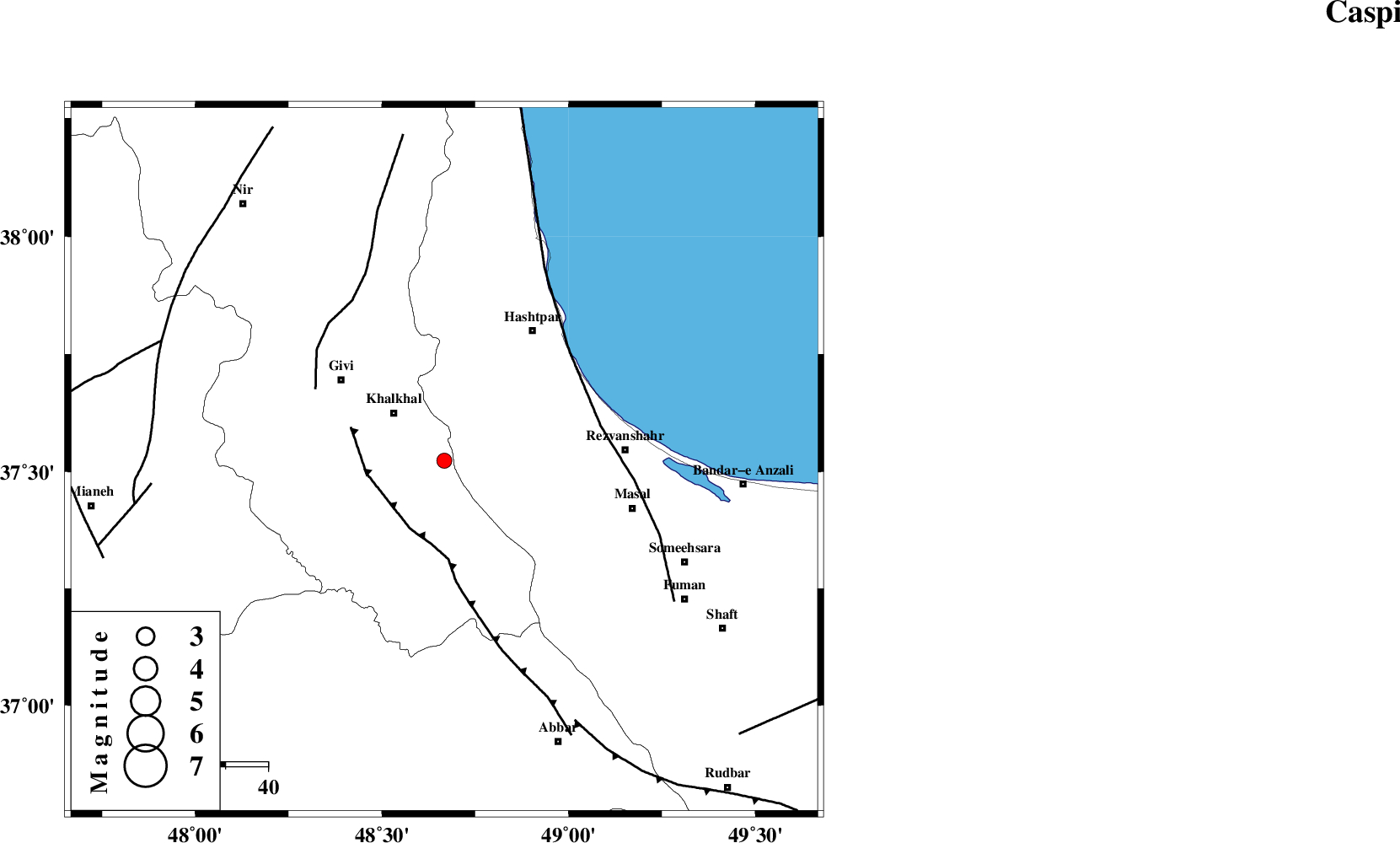
| Location | Lat:37.523 Lon: 48.667 |
| Region | Ardebil Province, 17 km South-East of Khalkhal |
Nearest Cities |
|
| 13 km East of Khojin, Ardebil Province | |
| 16 km North of Kalur, Ardebil Province | |
| 17 km South East of Khalkhal, Ardebil Province | |
| 19 km West of Ardeh, Gilan Province | |
| 23 km North of Karin, Ardebil Province | |
| Depth | 27 km |
| Agency | |
Faults within 150 km: |
|
| MASULEL_F (Length: 90 km) , Distance to epicenter: 17 km | |
| SANGAVAR_F (Length: 61 km) , Distance to epicenter: 35 km | |
| TALESH_F (Length: 258 km) , Distance to epicenter: 38 km | |
| Number of Phases | 6 |
| RMS | 0.3 |
| Number of Stations | 5 |
| Error in Latitude | >2.7 km |
| Error in Longitude | 7 km |
| Error in Depth | 7 km |
Download waveform in seisan format
to download seisan software Click here
to access information about IIEES stations Click here
Amplitude | ||||||||
| UID | Agency | Station | Component | Amplitude | Period | Arrival Time | Proccessing Time | Signal Clip |
| 100364 | IIEES | GRMI | E | 61.5 | 0.3 | 2015-08-15 23:10:22 | 2015-08-17 06:55:00 | n |
| 100365 | IIEES | CHTH | E | 26 | 0.31 | 2015-08-15 23:11:04 | 2015-08-17 06:55:00 | n |
Phase | ||||||||||||
| Agency | Station | Component | Phase Type | Phase Quality | First Motion | Observed Arrival Time | Time Residual | Loc. Flag | Input Weight | Distance | Azimuth | |
| IIEES | ZNJK | Z | Pg | E | 2015-08-15 23:09:50 | 0.02 | y | 94.5 | 179 | |||
| IIEES | GRMI | Z | Pg | E | 2015-08-15 23:10:00 | -0.08 | y | 158 | 335 | |||
| IIEES | GRMI | N | Sg | E | 2015-08-15 23:10:19 | 0.06 | y | 158 | 335 | |||
| IIEES | THKV | Z | Pn | E | 2015-08-15 23:10:13 | -0.43 | y | 266 | 131 | |||
| IIEES | CHTH | Z | Pn | E | 2015-08-15 23:10:17 | 0.44 | y | 283 | 128 | |||
| IIEES | SNGE | Z | Pn | E | 2015-08-15 23:10:17 | 0.01 | y | 295 | 204 | |||