
Magnitude |
:4.1 |
| Date & Time (UTC) | 2015-08-13 18:42:11.7 |
| Date & Time (Local) | 1394/5/22 23:12:11.7 |
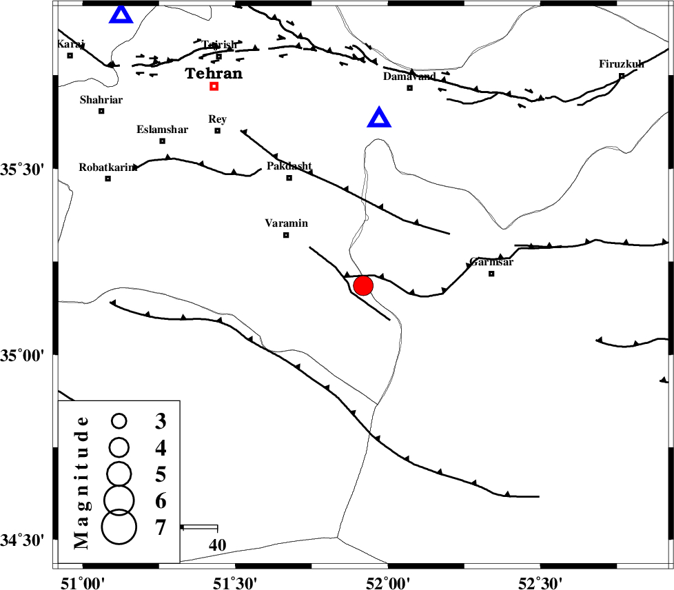
| Location | Lat:35.185 Lon: 51.919 |
| Region | Tehran Province, 28 km South-East of Varamin |
Nearest Cities |
|
| 11 km of Shorqazi, Semnan Province | |
| 14 km South of Cheshmeh nadi, Semnan Province | |
| 21 km South West of Evanekay, Semnan Province | |
| 22 km South East of Pishva, Tehran Province | |
| 23 km South East of Khalilabad, Tehran Province | |
| Depth | 9 km |
| Agency | |
Faults within 150 km: |
|
| GARMSAR_F (Length: 77 km) , Distance to epicenter: 3 km | |
| PISHAV_F (Length: 34 km) , Distance to epicenter: 4 km | |
| EYVANEKEY_F (Length: 74 km) , Distance to epicenter: 23 km | |
| Number of Phases | 8 |
| RMS | 0.5 |
| Number of Stations | 7 |
| Error in Latitude | >4.2 km |
| Error in Longitude | 6 km |
| Error in Depth | 8.9 km |
Download waveform in seisan format
to download seisan software Click here
to access information about IIEES stations Click here
Amplitude | ||||||||
| UID | Agency | Station | Component | Amplitude | Period | Arrival Time | Proccessing Time | Signal Clip |
| 100310 | IIEES | GHVR | N | 5760.3 | 0.26 | 2015-08-13 18:42:48 | 2015-08-14 10:44:00 | n |
Phase | ||||||||||||
| Agency | Station | Component | Phase Type | Phase Quality | First Motion | Observed Arrival Time | Time Residual | Loc. Flag | Input Weight | Distance | Azimuth | |
| IIEES | DAMV | Z | Pg | E | 2015-08-13 18:42:21 | 0.57 | y | 49.6 | 5 | |||
| IIEES | GHVR | Z | Pg | E | 2015-08-13 18:42:28 | -0.41 | y | 99.5 | 218 | |||
| IIEES | THKV | Z | Pg | E | 2015-08-13 18:42:32 | -0.43 | y | 124 | 311 | |||
| IIEES | THKV | N | Sg | E | 2015-08-13 18:42:49 | 0.17 | y | 124 | 311 | |||
| IIEES | KHMZ | Z | Pn | E | 2015-08-13 18:42:50 | 0.49 | y | 241 | 229 | |||
| IIEES | NASN | Z | Pn | E | 2015-08-13 18:42:55 | 0.52 | y | 277 | 162 | |||
| IIEES | ZNJK | Z | Pn | E | 2015-08-13 18:43:01 | -0.34 | y | 335 | 300 | |||
| IIEES | SHRO | Z | Pn | E | 2015-08-13 18:43:06 | -0.71 | y | 382 | 75 | |||