
Magnitude |
:2.4 |
| Date & Time (UTC) | 2015-08-10 11:57:37.3 |
| Date & Time (Local) | 1394/5/19 16:27:37.3 |
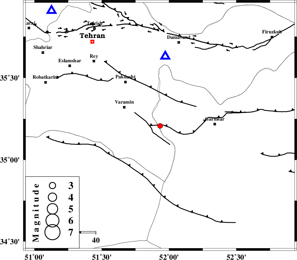
| Location | Lat:35.207 Lon: 51.933 |
| Region | Semnan Province, 27 km South-East of Varamin |
Nearest Cities |
|
| 9 km of Shorqazi, Semnan Province | |
| 11 km of Cheshmeh nadi, Semnan Province | |
| 19 km South West of Evanekay, Semnan Province | |
| 21 km East of Pishva, Tehran Province | |
| 23 km South East of Khalilabad, Tehran Province | |
| Depth | 26 km |
| Agency | |
Faults within 150 km: |
|
| GARMSAR_F (Length: 77 km) , Distance to epicenter: 2 km | |
| PISHAV_F (Length: 34 km) , Distance to epicenter: 6 km | |
| EYVANEKEY_F (Length: 74 km) , Distance to epicenter: 20 km | |
| Number of Phases | 9 |
| RMS | 0.5 |
| Number of Stations | 7 |
| Error in Latitude | >3.4 km |
| Error in Longitude | 5.5 km |
| Error in Depth | 8.8 km |
Download waveform in seisan format
to download seisan software Click here
to access information about IIEES stations Click here
Amplitude | ||||||||
| UID | Agency | Station | Component | Amplitude | Period | Arrival Time | Proccessing Time | Signal Clip |
| 100286 | IIEES | GHVR | N | 89.5 | 0.28 | 2015-08-10 11:58:12 | 2015-08-12 08:24:00 | n |
| 100287 | IIEES | ASAO | E | 39.5 | 0.49 | 2015-08-10 11:58:32 | 2015-08-12 08:24:00 | n |
Phase | ||||||||||||
| Agency | Station | Component | Phase Type | Phase Quality | First Motion | Observed Arrival Time | Time Residual | Loc. Flag | Input Weight | Distance | Azimuth | |
| IIEES | DAMV | Z | Pg | E | 2015-08-10 11:57:46 | 0.17 | y | 47 | 4 | |||
| IIEES | GHVR | Z | Pg | E | 2015-08-10 11:57:54 | -0.4 | y | 102 | 218 | |||
| IIEES | CHTH | Z | Pg | E | 2015-08-10 11:57:55 | -0.11 | y | 107 | 317 | |||
| IIEES | THKV | Z | Pg | E | 2015-08-10 11:57:58 | 0.32 | y | 124 | 310 | |||
| IIEES | ASAO | Z | Pg | E | 2015-08-10 11:58:07 | -0.28 | y | 189 | 248 | |||
| IIEES | ASAO | N | Sg | E | 2015-08-10 11:58:30 | 0.53 | y | 189 | 248 | |||
| IIEES | NASN | Z | Pn | E | 2015-08-10 11:58:19 | 0.81 | y | 279 | 163 | |||
| IIEES | NASN | N | Sg | E | 2015-08-10 11:58:54 | -0.33 | y | 279 | 163 | |||
| IIEES | ZNJK | Z | Pn | E | 2015-08-10 11:58:24 | -0.78 | y | 335 | 300 | |||