
Magnitude |
:2.8 |
| Date & Time (UTC) | 2015-08-08 10:32:41.3 |
| Date & Time (Local) | 1394/5/17 15:02:41.3 |
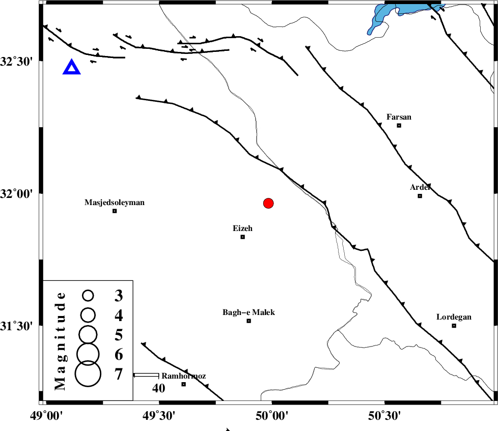
| Location | Lat:31.963 Lon: 49.984 |
| Region | Khoozestan Province, 18 km North-East of Izeh |
Nearest Cities |
|
| 16 km East of Torshak, Khoozestan Province | |
| 18 km North East of Izeh, Khoozestan Province | |
| 20 km North East of Rasvand, Khoozestan Province | |
| 27 km North East of Chenarestan, Khoozestan Province | |
| 36 km North West of Dehdez, Khoozestan Province | |
| Depth | 14 km |
| Agency | |
Faults within 150 km: |
|
| MFF2 (Length: 205 km) , Distance to epicenter: 17 km | |
| DOPOLAN_F (Length: 107 km) , Distance to epicenter: 25 km | |
| ZARDKUH_F (Length: 139 km) , Distance to epicenter: 26 km | |
| Number of Phases | 5 |
| RMS | 0 |
| Number of Stations | 4 |
| Error in Latitude | >3.6 km |
| Error in Longitude | 1.4 km |
| Error in Depth | 4.2 km |
Download waveform in seisan format
to download seisan software Click here
to access information about IIEES stations Click here
Amplitude | ||||||||
| UID | Agency | Station | Component | Amplitude | Period | Arrival Time | Proccessing Time | Signal Clip |
| 100279 | IIEES | SHGR | N | 265.7 | 0.36 | 2015-08-08 10:33:18 | 2015-08-09 06:31:00 | n |
Phase | ||||||||||||
| Agency | Station | Component | Phase Type | Phase Quality | First Motion | Observed Arrival Time | Time Residual | Loc. Flag | Input Weight | Distance | Azimuth | |
| IIEES | SHGR | Z | Pg | E | 2015-08-08 10:33:00 | -0.02 | y | 113 | 279 | |||
| IIEES | KHMZ | Z | Pg | E | 2015-08-08 10:33:13 | 0.02 | y | 197 | 359 | |||
| IIEES | NASN | Z | Pn | E | 2015-08-08 10:33:24 | -0.04 | y | 281 | 70 | |||
| IIEES | NASN | N | Sg | E | 2015-08-08 10:34:00 | -0.02 | y | 281 | 70 | |||
| IIEES | YZKH | Z | Pn | E | 2015-08-08 10:33:43 | 0.07 | y | 437 | 83 | |||