
Magnitude |
:3.2 |
| Date & Time (UTC) | 2015-08-07 19:47:05.9 |
| Date & Time (Local) | 1394/5/17 00:17:05.9 |
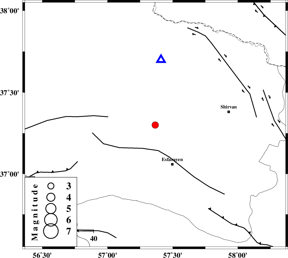
| Location | Lat:37.3 Lon: 57.366 |
| Region | Khorasan(north) Province, 19 km South of Bojnurd |
Nearest Cities |
|
| 19 km South of Void, Khorasan(north) Province | |
| 19 km South of Bojnurd, Khorasan(north) Province | |
| 21 km North of Eraj, Khorasan(north) Province | |
| 25 km North East of Cheharborj, Khorasan(north) Province | |
| 26 km South West of Hesar-egarmkhanh, Khorasan(north) Province | |
| Depth | 14 km |
| Agency | |
Faults within 150 km: |
|
| ESFARAYEN_F (Length: 111 km) , Distance to epicenter: 17 km | |
| ROBATE_QARABIL_F (Length: 168 km) , Distance to epicenter: 32 km | |
| JAJARAM_F (Length: 77 km) , Distance to epicenter: 58 km | |
| Number of Phases | 5 |
| RMS | 0.1 |
| Number of Stations | 4 |
| Error in Latitude | >2.2 km |
| Error in Longitude | 5.4 km |
| Error in Depth | 7.9 km |
Download waveform in seisan format
to download seisan software Click here
to access information about IIEES stations Click here
Amplitude | ||||||||
| UID | Agency | Station | Component | Amplitude | Period | Arrival Time | Proccessing Time | Signal Clip |
| 100271 | IIEES | SHRO | E | 235.3 | 0.54 | 2015-08-07 19:48:02 | 2015-08-08 11:31:00 | n |
Phase | ||||||||||||
| Agency | Station | Component | Phase Type | Phase Quality | First Motion | Observed Arrival Time | Time Residual | Loc. Flag | Input Weight | Distance | Azimuth | |
| IIEES | BJRD | Z | Pg | E | 2015-08-07 19:47:14 | -0.1 | y | 44.5 | 5 | |||
| IIEES | MRVT | Z | Pg | E | 2015-08-07 19:47:26 | 0.08 | y | 120 | 290 | |||
| IIEES | SHRO | Z | Pg | E | 2015-08-07 19:47:36 | 0.15 | y | 188 | 221 | |||
| IIEES | SHRO | N | Sg | E | 2015-08-07 19:47:59 | -0.16 | y | 188 | 221 | |||
| IIEES | TABS | Z | Pn | E | 2015-08-07 19:48:04 | 0.04 | y | 406 | 183 | |||