
Magnitude |
:3.1 |
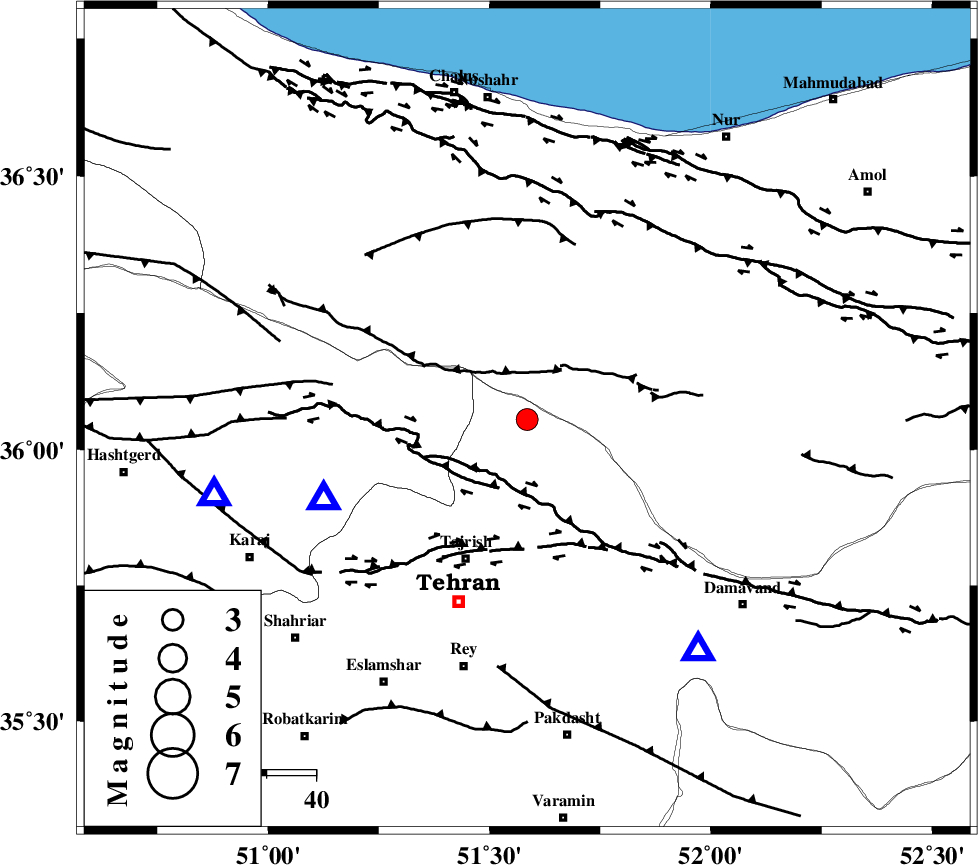
| Date & Time (UTC) | 2015-08-02 01:32:54.6 |
| Date & Time (Local) | 1394/5/11 06:02:54.6 |
| Location | Lat:36.055 Lon: 51.585 |
| Region | Tehran Province, 31 km North-East of Tajrish |
Nearest Cities |
|
| 14 km North of Meygon, Tehran Province | |
| 14 km North of Fasham, Tehran Province | |
| 18 km East of Nesa, Tehran Province | |
| 20 km South of Void, Mazandaran Province | |
| 22 km North East of Asara, Tehran Province | |
| Depth | 14 km |
| Agency | |
Faults within 150 km: |
|
| KANDOVAN_F (Length: 90 km) , Distance to epicenter: 11 km | |
| MOSHA_F (Length: 234 km) , Distance to epicenter: 13 km | |
| N_TEHRAN_F4 (Length: 115 km) , Distance to epicenter: 27 km | |
| Number of Phases | 6 |
| RMS | 0.4 |
| Number of Stations | 5 |
| Error in Latitude | >8.7 km |
| Error in Longitude | 4.4 km |
| Error in Depth | 9.4 km |
Download waveform in seisan format
to download seisan software Click here
to access information about IIEES stations Click here
Amplitude | ||||||||
| UID | Agency | Station | Component | Amplitude | Period | Arrival Time | Proccessing Time | Signal Clip |
| 100233 | IIEES | GHVR | N | 397.6 | 0.49 | 2015-08-02 01:33:50 | 2015-08-02 07:17:00 | n |
| 100234 | IIEES | ASAO | E | 78 | 0.46 | 2015-08-02 01:34:01 | 2015-08-02 07:17:00 | n |
Phase | ||||||||||||
| Agency | Station | Component | Phase Type | Phase Quality | First Motion | Observed Arrival Time | Time Residual | Loc. Flag | Input Weight | Distance | Azimuth | |
| IIEES | CHTH | Z | Pg | E | 2015-08-02 01:33:02 | -0.02 | y | 44.5 | 249 | |||
| IIEES | CHTH | E | Sg | E | 2015-08-02 01:33:08 | -0.28 | y | 44.5 | 249 | |||
| IIEES | DAMV | Z | Pg | E | 2015-08-02 01:33:05 | 0.07 | y | 58.6 | 143 | |||
| IIEES | ASAO | Z | Pn | E | 2015-08-02 01:33:30 | 0.64 | y | 219 | 221 | |||
| IIEES | ASAO | N | Sg | E | 2015-08-02 01:33:57 | 0.11 | y | 219 | 221 | |||
| IIEES | NASN | Z | Pn | E | 2015-08-02 01:33:49 | -0.62 | y | 378 | 162 | |||