
Magnitude |
:2.6 |
| Date & Time (UTC) | 2015-07-26 22:27:31.9 |
| Date & Time (Local) | 1394/5/5 02:57:31.9 |
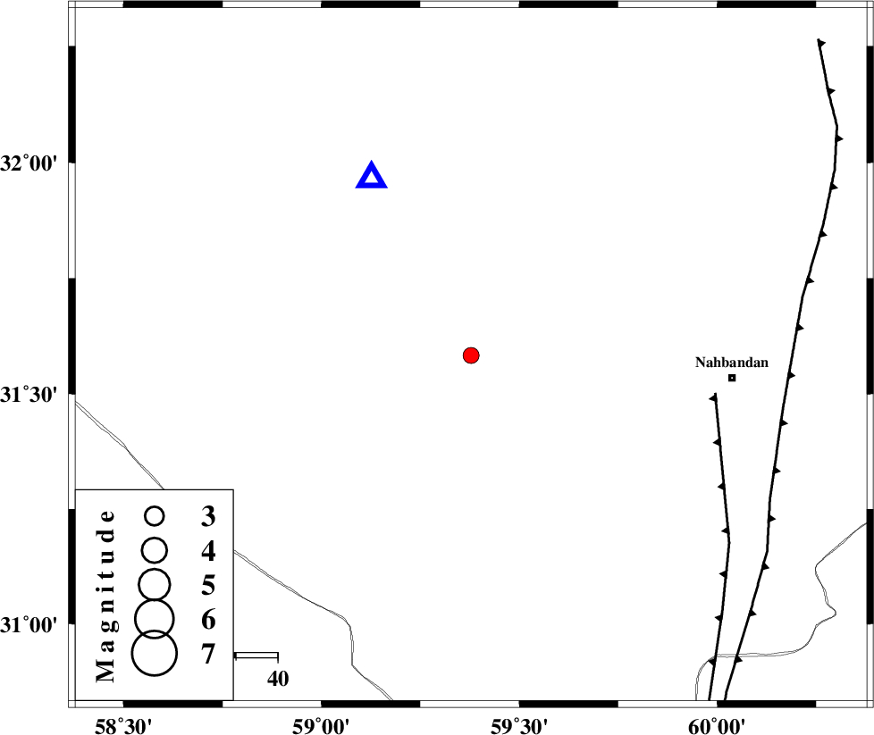
| Location | Lat:31.583 Lon: 59.378 |
| Region | Khorasan(south) Province, 63 km -West of Nehbandan |
Nearest Cities |
|
| 63 km North West of Nehbandan, Khorasan(south) Province | |
| 67 km South West of Shusef, Khorasan(south) Province | |
| 98 km South of Mokhtaran, Khorasan(south) Province | |
| 106 km South West of Kalateh soleyman, Khorasan(south) Province | |
| 111 km South East of Hamand, Khorasan(south) Province | |
| Depth | 9 km |
| Agency | |
Faults within 150 km: |
|
| W_NEH_F (Length: 158 km) , Distance to epicenter: 59 km | |
| E_NEH_F (Length: 148 km) , Distance to epicenter: 76 km | |
| SEFIDABAD_F (Length: 26 km) , Distance to epicenter: 126 km | |
| Number of Phases | 4 |
| RMS | 0 |
| Number of Stations | 3 |
| Error in Latitude | >2.7 km |
| Error in Longitude | 9.3 km |
| Error in Depth | 4.5 km |
Download waveform in seisan format
to download seisan software Click here
to access information about IIEES stations Click here
Amplitude | ||||||||
| UID | Agency | Station | Component | Amplitude | Period | Arrival Time | Proccessing Time | Signal Clip |
| 100189 | IIEES | BSRN | E | 643 | 0.15 | 2015-07-26 22:27:48 | 2015-07-28 10:50:00 | n |
| 100190 | IIEES | BSRN | N | 508.1 | 0.2 | 2015-07-26 22:27:48 | 2015-07-28 10:50:00 | n |
| 100191 | IIEES | KRBR | N | 15.8 | 0.31 | 2015-07-26 22:28:55 | 2015-07-28 10:50:00 | n |
| 100192 | IIEES | KRBR | E | 22.4 | 0.54 | 2015-07-26 22:28:55 | 2015-07-28 10:50:00 | n |
Phase | ||||||||||||
| Agency | Station | Component | Phase Type | Phase Quality | First Motion | Observed Arrival Time | Time Residual | Loc. Flag | Input Weight | Distance | Azimuth | |
| IIEES | BSRN | Z | Pg | E | 2015-07-26 22:27:40 | 0 | y | 48.6 | 331 | |||
| IIEES | BSRN | N | Sg | E | 2015-07-26 22:27:47 | 0 | y | 48.6 | 331 | |||
| IIEES | KRBR | Z | Pn | E | 2015-07-26 22:28:18 | 0 | y | 307 | 235 | |||
| IIEES | TABS | Z | Pn | E | 2015-07-26 22:28:18 | 0 | y | 312 | 318 | |||