
Magnitude |
:3.8 |
| Date & Time (UTC) | 2015-07-24 15:10:03.9 |
| Date & Time (Local) | 1394/5/2 19:40:03.9 |
| Location | Lat:28.002 Lon: 52.02 |
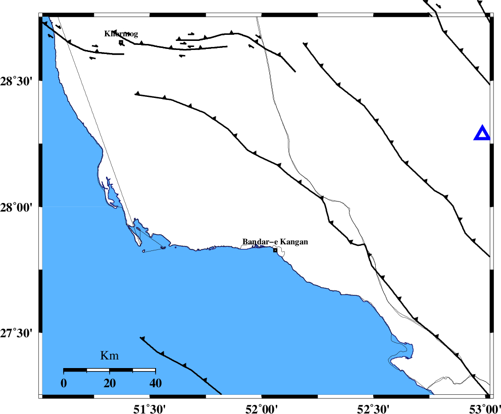
| Region | Bushehr Province, 20 km North of Bandar-e kangan |
Nearest Cities |
|
| 7 km of Riz, Bushehr Province | |
| 20 km North of Bandar-e kangan, Bushehr Province | |
| 27 km East of Abdan, Bushehr Province | |
| 31 km South West of Dolatabad, Fars Province | |
| 35 km North West of Jam, Bushehr Province | |
| Depth | 6 km |
| Agency | |
Faults within 150 km: |
|
| MFF3 (Length: 292 km) , Distance to epicenter: 9 km | |
| MFF5 (Length: 74 km) , Distance to epicenter: 40 km | |
| BORAZJAN_F (Length: 168 km) , Distance to epicenter: 50 km | |
| Number of Phases | 6 |
| RMS | 0.2 |
| Number of Stations | 6 |
| Error in Latitude | >7.5 km |
| Error in Longitude | 5.9 km |
| Error in Depth | 7.2 km |
Download waveform in seisan format
to download seisan software Click here
to access information about IIEES stations Click here
Amplitude | ||||||||
| UID | Agency | Station | Component | Amplitude | Period | Arrival Time | Proccessing Time | Signal Clip |
| 100180 | IIEES | AHRM | N | 3756.1 | 0.39 | 2015-07-24 15:10:49 | 2015-07-26 07:34:00 | n |
| 100181 | IIEES | KRBR | E | 43.3 | 0.27 | 2015-07-24 15:12:15 | 2015-07-26 07:34:00 | n |
Phase | ||||||||||||
| Agency | Station | Component | Phase Type | Phase Quality | First Motion | Observed Arrival Time | Time Residual | Loc. Flag | Input Weight | Distance | Azimuth | |
| IIEES | AHRM | Z | Pg | E | 2015-07-24 15:10:24 | -0.06 | y | 119 | 324 | |||
| IIEES | BNDS | Z | Pn | E | 2015-07-24 15:11:04 | -0.11 | y | 415 | 98 | |||
| IIEES | KRBR | Z | Pn | E | 2015-07-24 15:11:16 | 0.33 | y | 511 | 63 | |||
| IIEES | YZKH | Z | Pn | E | 2015-07-24 15:11:20 | -0.12 | y | 546 | 26 | |||
| IIEES | SHGR | Z | Pn | E | 2015-07-24 15:11:21 | 0.16 | y | 551 | 327 | |||
| IIEES | BSRN | Z | Pn | E | 2015-07-24 15:11:53 | -0.27 | y | 814 | 56 | |||