
Magnitude |
:2.6 |
| Date & Time (UTC) | 2015-07-21 20:06:17.6 |
| Date & Time (Local) | 1394/4/31 00:36:17.6 |
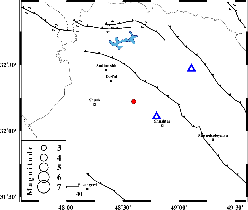
| Location | Lat:32.222 Lon: 48.597 |
| Region | Khoozestan Province, 26 km South-East of Dezful |
Nearest Cities |
|
| 18 km East of Shamsabad, Khoozestan Province | |
| 20 km South of Mahur berenji, Khoozestan Province | |
| 20 km West of Gatvand, Khoozestan Province | |
| 24 km North West of Samaleh, Khoozestan Province | |
| 26 km South East of Dezful, Khoozestan Province | |
| Depth | 14 km |
| Agency | |
Faults within 150 km: |
|
| DEZFUL_EMBAYMENT (Length: 228 km) , Distance to epicenter: 19 km | |
| BALARUD_F_Z2 (Length: 58 km) , Distance to epicenter: 58 km | |
| BALARUD_F_Z3 (Length: 53 km) , Distance to epicenter: 62 km | |
| Number of Phases | 6 |
| RMS | 0.3 |
| Number of Stations | 5 |
| Error in Latitude | >3.6 km |
| Error in Longitude | 9.2 km |
| Error in Depth | 7.3 km |
Download waveform in seisan format
to download seisan software Click here
to access information about IIEES stations Click here
Amplitude | ||||||||
| UID | Agency | Station | Component | Amplitude | Period | Arrival Time | Proccessing Time | Signal Clip |
| 100157 | IIEES | SHGR | N | 1839.3 | 0.52 | 2015-07-21 20:06:39 | 2015-07-22 08:16:00 | n |
| 100158 | IIEES | GHVR | E | 10.9 | 0.44 | 2015-07-21 20:08:02 | 2015-07-22 08:16:00 | n |
| 100159 | IIEES | GHVR | N | 10.6 | 0.48 | 2015-07-21 20:08:07 | 2015-07-22 08:16:00 | n |
Phase | ||||||||||||
| Agency | Station | Component | Phase Type | Phase Quality | First Motion | Observed Arrival Time | Time Residual | Loc. Flag | Input Weight | Distance | Azimuth | |
| IIEES | SHGR | Z | Pg | E | 2015-07-21 20:06:22 | -0.25 | y | 23 | 123 | |||
| IIEES | KHMZ | Z | Pn | E | 2015-07-21 20:06:51 | 0.12 | y | 211 | 37 | |||
| IIEES | ASAO | Z | Pn | E | 2015-07-21 20:07:01 | 0.35 | y | 290 | 27 | |||
| IIEES | ASAO | E | Sg | E | 2015-07-21 20:07:39 | -0.3 | y | 290 | 27 | |||
| IIEES | SNGE | Z | Pn | E | 2015-07-21 20:07:07 | -0.28 | y | 339 | 340 | |||
| IIEES | GHVR | Z | Pn | E | 2015-07-21 20:07:09 | 0.38 | y | 351 | 44 | |||