
Magnitude |
:3.2 |
| Date & Time (UTC) | 2015-07-18 00:41:03.9 |
| Date & Time (Local) | 1394/4/27 05:11:03.9 |
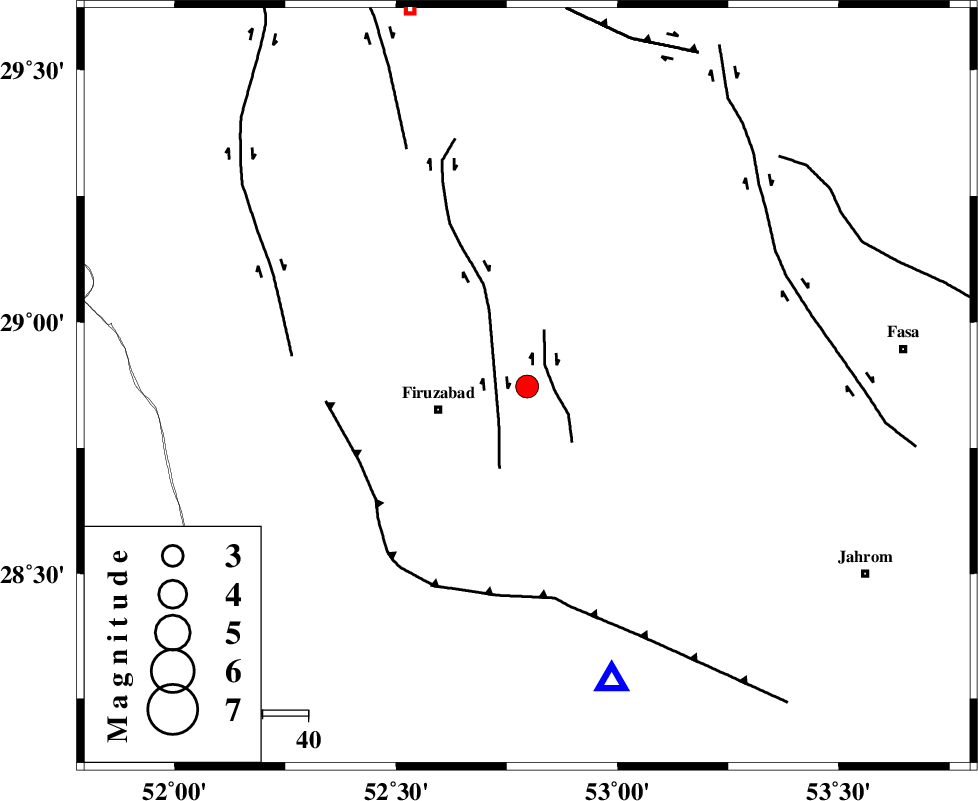
| Location | Lat:28.872 Lon: 52.796 |
| Region | Fars Province, 20 km -East of Firuz Abad |
Nearest Cities |
|
| 5 km of Meymand, Fars Province | |
| 6 km North of Parzeytun, Fars Province | |
| 20 km North East of Jaydasht, Fars Province | |
| 20 km North East of Firuz Abad, Fars Province | |
| 24 km South of Dehshib, Fars Province | |
| Depth | 14 km |
| Agency | |
Faults within 150 km: |
|
| SABZ_PUSHAN_F_Z2 (Length: 24 km) , Distance to epicenter: 6 km | |
| SABZ_PUSHAN_F_Z1 (Length: 69 km) , Distance to epicenter: 10 km | |
| QIR_F (Length: 130 km) , Distance to epicenter: 40 km | |
| Number of Phases | 7 |
| RMS | 0.3 |
| Number of Stations | 5 |
| Error in Latitude | >9.4 km |
| Error in Longitude | 2.5 km |
| Error in Depth | 8.6 km |
Download waveform in seisan format
to download seisan software Click here
to access information about IIEES stations Click here
Amplitude | ||||||||
| UID | Agency | Station | Component | Amplitude | Period | Arrival Time | Proccessing Time | Signal Clip |
| 100120 | IIEES | AHRM | N | 400.9 | 0.47 | 2015-07-18 00:41:56 | 2015-07-21 11:03:00 | n |
Phase | ||||||||||||
| Agency | Station | Component | Phase Type | Phase Quality | First Motion | Observed Arrival Time | Time Residual | Loc. Flag | Input Weight | Distance | Azimuth | |
| IIEES | AHRM | Z | Pg | E | 2015-07-18 00:41:27 | -0.17 | y | 146 | 270 | |||
| IIEES | AHRM | N | Sg | E | 2015-07-18 00:41:45 | 0.02 | y | 146 | 270 | |||
| IIEES | KRBR | Z | Pn | E | 2015-07-18 00:42:02 | 0.57 | y | 404 | 71 | |||
| IIEES | KRBR | N | Sg | E | 2015-07-18 00:42:56 | -0.42 | y | 404 | 71 | |||
| IIEES | NASN | Z | Pn | E | 2015-07-18 00:42:05 | 0.03 | y | 435 | 0 | |||
| IIEES | KHMZ | Z | Pn | E | 2015-07-18 00:42:26 | -0.22 | y | 603 | 334 | |||
| IIEES | GHVR | Z | Pn | E | 2015-07-18 00:42:31 | 0.24 | y | 639 | 347 | |||