
Magnitude |
:3.3 |
| Date & Time (UTC) | 2015-07-17 23:48:26.0 |
| Date & Time (Local) | 1394/4/27 04:18:26.0 |
| Location | Lat:31.328 Lon: 56.481 |
| Region | Kerman Province, 32 km -West of Ravar |
Nearest Cities |
|
| 19 km East of Jor, Kerman Province | |
| 20 km East of Kuhbanan, Kerman Province | |
| 21 km North of Toghroljerd, Kerman Province | |
| 30 km North West of Dehali, Kerman Province | |
| 31 km North of Dasht-e khak, Kerman Province | |
| Depth | 16 km |
| Agency | |
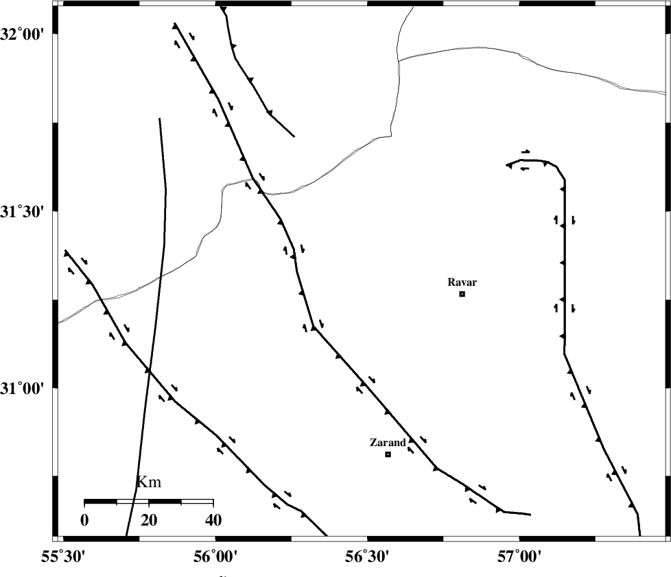
Faults within 150 km: |
|
| KUHBANAN_F (Length: 189 km) , Distance to epicenter: 20 km | |
| JAFARABAD_F (Length: 60 km) , Distance to epicenter: 47 km | |
| LAKARKUH_F (Length: 138 km) , Distance to epicenter: 56 km | |
| Number of Phases | 6 |
| RMS | 0.1 |
| Number of Stations | 5 |
| Error in Latitude | >2.7 km |
| Error in Longitude | 3.1 km |
| Error in Depth | 5.9 km |
Download waveform in seisan format
to download seisan software Click here
to access information about IIEES stations Click here
Amplitude | ||||||||
| UID | Agency | Station | Component | Amplitude | Period | Arrival Time | Proccessing Time | Signal Clip |
| 100118 | IIEES | YZKH | N | 206.8 | 0.31 | 2015-07-17 23:49:28 | 2015-07-21 11:03:00 | n |
| 100119 | IIEES | YZKH | E | 295.3 | 0.44 | 2015-07-17 23:49:29 | 2015-07-21 11:03:00 | n |
Phase | ||||||||||||
| Agency | Station | Component | Phase Type | Phase Quality | First Motion | Observed Arrival Time | Time Residual | Loc. Flag | Input Weight | Distance | Azimuth | |
| IIEES | KRBR | Z | Pg | E | 2015-07-17 23:48:51 | 0.01 | y | 152 | 170 | |||
| IIEES | YZKH | Z | P | E | 2015-07-17 23:49:00 | 0.01 | y | 214 | 304 | |||
| IIEES | YZKH | N | Sg | E | 2015-07-17 23:49:26 | -0.01 | y | 214 | 304 | |||
| IIEES | TABS | Z | Pn | E | 2015-07-17 23:49:06 | 0.2 | y | 264 | 13 | |||
| IIEES | SHRT | Z | Pn | E | 2015-07-17 23:49:28 | -0.1 | y | 441 | 53 | |||
| IIEES | SHRO | Z | Pn | E | 2015-07-17 23:49:38 | -0.2 | y | 521 | 355 | |||