
Magnitude |
:3 |
| Date & Time (UTC) | 2015-07-17 20:29:27.9 |
| Date & Time (Local) | 1394/4/27 00:59:27.9 |
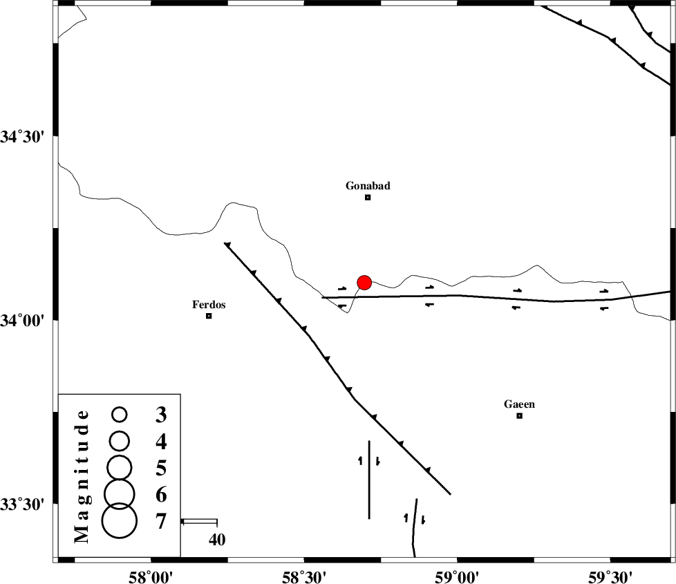
| Location | Lat:34.102 Lon: 58.696 |
| Region | Khorasan(center) Province, 26 km South of Gonabad |
Nearest Cities |
|
| 5 km of Marghash, Khorasan(center) Province | |
| 9 km of Kakhak, Khorasan(center) Province | |
| 13 km North West of Khazridasht-ebayaz, Khorasan(center) Province | |
| 13 km North West of Khazridasht-ebayaz, Khorasan(south) Province | |
| 21 km North East of Masbaei, Khorasan(center) Province | |
| Depth | 15 km |
| Agency | |
Faults within 150 km: |
|
| DASHT_E_BAYAZ_F (Length: 177 km) , Distance to epicenter: 14 km | |
| FERDOWS_F (Length: 101 km) , Distance to epicenter: 23 km | |
| DUSTABAD_F (Length: 22 km) , Distance to epicenter: 48 km | |
| Number of Phases | 6 |
| RMS | 0.6 |
| Number of Stations | 7 |
| Error in Latitude | >7.4 km |
| Error in Longitude | 6 km |
| Error in Depth | 9.1 km |
Download waveform in seisan format
to download seisan software Click here
to access information about IIEES stations Click here
Amplitude | ||||||||
| UID | Agency | Station | Component | Amplitude | Period | Arrival Time | Proccessing Time | Signal Clip |
| 100117 | IIEES | YZKH | E | 22.5 | 0.65 | 2015-07-17 20:31:40 | 2015-07-21 11:03:00 | n |
Phase | ||||||||||||
| Agency | Station | Component | Phase Type | Phase Quality | First Motion | Observed Arrival Time | Time Residual | Loc. Flag | Input Weight | Distance | Azimuth | |
| IIEES | TABS | Z | Pg | E | 2015-07-17 20:29:53 | -0.3 | y | 154 | 251 | |||
| IIEES | SHRT | Z | Pg | E | 2015-07-17 20:29:53 | -0.44 | y | 156 | 108 | |||
| IIEES | SHRO | Z | Pn | E | 2015-07-17 20:30:15 | -0.54 | y | 323 | 312 | |||
| IIEES | MRVT | Z | Pn | E | 2015-07-17 20:30:33 | 0.9 | y | 460 | 330 | |||
| IIEES | KRBR | Z | Pn | E | 2015-07-17 20:30:37 | 0.17 | y | 492 | 202 | |||
| IIEES | ZHSF | Z | Pn | E | 2015-07-17 20:30:42 | 0.74 | y | 535 | 158 | |||