
Magnitude |
:3.9 |
| Date & Time (UTC) | 2015-06-30 07:55:30.6 |
| Date & Time (Local) | 1394/4/9 12:25:30.6 |
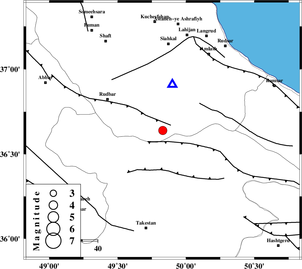
| Location | Lat:36.64 Lon: 49.83 |
| Region | Gilan Province, 44 km North-West of Qazvin |
Nearest Cities |
|
| 8 km of Jirhandeh, Gilan Province | |
| 17 km West of Kelishom, Gilan Province | |
| 25 km South of Barresar, Gilan Province | |
| 27 km North East of Kuhgir-e sofla, Ghazvin Province | |
| 28 km North East of Loshan, Gilan Province | |
| Depth | 15 km |
| Agency | |
Faults within 150 km: |
|
| RUDBAR_F (Length: 93 km) , Distance to epicenter: 6 km | |
| ALAMUTRUD_F (Length: 140 km) , Distance to epicenter: 8 km | |
| N_QAZVIN_F (Length: 72 km) , Distance to epicenter: 26 km | |
| Number of Phases | 6 |
| RMS | 0.3 |
| Number of Stations | 7 |
| Error in Latitude | >9.7 km |
| Error in Longitude | 4.8 km |
| Error in Depth | 5.7 km |
Download waveform in seisan format
to download seisan software Click here
to access information about IIEES stations Click here
Amplitude | ||||||||
| UID | Agency | Station | Component | Amplitude | Period | Arrival Time | Proccessing Time | Signal Clip |
| 96080 | IIEES | GHVR | E | 596.2 | 0.71 | 2015-06-30 07:56:56 | 2015-06-30 09:28:00 | n |
| 96081 | IIEES | GHVR | N | 621.1 | 0.5 | 2015-06-30 07:56:57 | 2015-06-30 09:28:00 | n |
| 96082 | IIEES | MRVT | E | 65.6 | 0.25 | 2015-06-30 07:57:49 | 2015-06-30 09:28:00 | n |
Phase | ||||||||||||
| Agency | Station | Component | Phase Type | Phase Quality | First Motion | Observed Arrival Time | Time Residual | Loc. Flag | Input Weight | Distance | Azimuth | |
| IIEES | ZNJK | Z | Pg | E | 2015-06-30 07:55:48 | -0.01 | y | 103 | 272 | |||
| IIEES | CHTH | Z | Pg | E | 2015-06-30 07:55:54 | -0.32 | y | 142 | 125 | |||
| IIEES | DAMV | Z | Pg | E | 2015-06-30 07:56:07 | 0 | y | 223 | 120 | |||
| IIEES | GHVR | Z | Pn | E | 2015-06-30 07:56:12 | 0.67 | y | 272 | 152 | |||
| IIEES | KHMZ | Z | Pn | E | 2015-06-30 07:56:18 | -0.39 | y | 322 | 178 | |||
| IIEES | SHRO | Z | Pn | E | 2015-06-30 07:56:47 | 0.03 | y | 559 | 95 | |||