
Magnitude |
:2.6 |
| Date & Time (UTC) | 2015-06-09 00:48:12.3 |
| Date & Time (Local) | 1394/3/19 05:18:12.3 |
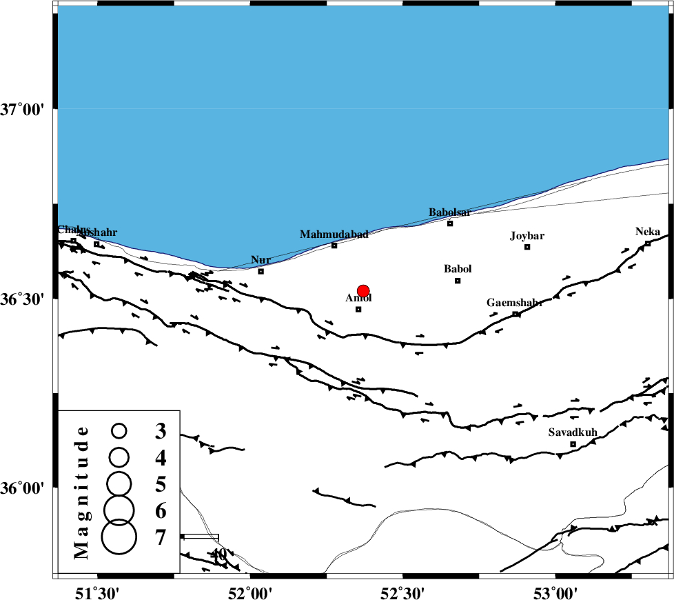
| Location | Lat:36.52 Lon: 52.37 |
| Region | Mazandaran Province, 6 km Amol |
Nearest Cities |
|
| 6 km North of Amol, Mazandaran Province | |
| 13 km South of Bisheh kola, Mazandaran Province | |
| 14 km North of Oskumahalleh, Mazandaran Province | |
| 15 km East of Azadmun, Mazandaran Province | |
| 16 km South West of Kargard-e mahalleh, Mazandaran Province | |
| Depth | 6 km |
| Agency | |
Faults within 150 km: |
|
| KHAZAR_F (Length: 523 km) , Distance to epicenter: 14 km | |
| N_ALBORZ_F (Length: 360 km) , Distance to epicenter: 28 km | |
| KOJOOR (Length: 75 km) , Distance to epicenter: 62 km | |
| Number of Phases | 5 |
| RMS | 0.1 |
| Number of Stations | 6 |
| Error in Latitude | >4.1 km |
| Error in Longitude | 3.8 km |
| Error in Depth | 5 km |
Download waveform in seisan format
to download seisan software Click here
to access information about IIEES stations Click here
Amplitude | ||||||||
| UID | Agency | Station | Component | Amplitude | Period | Arrival Time | Proccessing Time | Signal Clip |
| 95917 | IIEES | THKV | N | 101.1 | 0.4 | 2015-06-09 00:48:56 | 2015-06-09 02:13:00 | n |
| 95918 | IIEES | GHVR | E | 31.9 | 0.44 | 2015-06-09 00:49:28 | 2015-06-09 02:13:00 | n |
| 95919 | IIEES | ASAO | N | 24.4 | 0.52 | 2015-06-09 00:49:39 | 2015-06-09 02:13:00 | n |
Phase | ||||||||||||
| Agency | Station | Component | Phase Type | Phase Quality | First Motion | Observed Arrival Time | Time Residual | Loc. Flag | Input Weight | Distance | Azimuth | |
| IIEES | CHTH | Z | Pg | E | 2015-06-09 00:48:34 | -0.23 | y | 131 | 239 | |||
| IIEES | GHVR | Z | Pn | E | 2015-06-09 00:48:51 | 0.09 | y | 249 | 205 | |||
| IIEES | ASAO | Z | Pn | E | 2015-06-09 00:48:59 | 0.1 | y | 305 | 225 | |||
| IIEES | ZNJK | Z | Pn | E | 2015-06-09 00:49:02 | 0.12 | y | 330 | 274 | |||
| IIEES | MRVT | Z | Pn | E | 2015-06-09 00:49:04 | -0.07 | y | 354 | 68 | |||