
Magnitude |
:2.5 |
| Date & Time (UTC) | 2015-05-29 03:15:49.0 |
| Date & Time (Local) | 1394/3/8 07:45:49.0 |
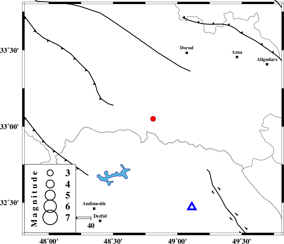
| Location | Lat:33.05 Lon: 48.81 |
| Region | Lorestan Province, 54 km South-West of Dorud |
Nearest Cities |
|
| 12 km North West of Bargsar, Lorestan Province | |
| 15 km South of Chamsangar, Lorestan Province | |
| 28 km North of Shuy, Khoozestan Province | |
| 28 km South West of Sartang barzeh, Lorestan Province | |
| 37 km South West of Shulabad, Lorestan Province | |
| Depth | 14 km |
| Agency | |
Faults within 150 km: |
|
| HZF4 (Length: 492 km) , Distance to epicenter: 26 km | |
| BALARUD_F_Z2 (Length: 58 km) , Distance to epicenter: 29 km | |
| MFF2 (Length: 205 km) , Distance to epicenter: 30 km | |
| Number of Phases | 5 |
| RMS | 0.1 |
| Number of Stations | 5 |
| Error in Latitude | >1.6 km |
| Error in Longitude | 4.6 km |
| Error in Depth | 5.8 km |
Download waveform in seisan format
to download seisan software Click here
to access information about IIEES stations Click here
Amplitude | ||||||||
| UID | Agency | Station | Component | Amplitude | Period | Arrival Time | Proccessing Time | Signal Clip |
| 95812 | IIEES | GHVR | E | 21.2 | 0.44 | 2015-05-29 03:17:14 | 2015-05-29 08:18:00 | n |
Phase | ||||||||||||
| Agency | Station | Component | Phase Type | Phase Quality | First Motion | Observed Arrival Time | Time Residual | Loc. Flag | Input Weight | Distance | Azimuth | |
| IIEES | SHGR | N | Sg | E | 2015-05-29 03:16:19 | -0.01 | y | 104 | 181 | |||
| IIEES | KHMZ | Z | Pg | E | 2015-05-29 03:16:11 | -0.06 | y | 132 | 54 | |||
| IIEES | ASAO | Z | Pn | E | 2015-05-29 03:16:21 | 0.16 | y | 201 | 34 | |||
| IIEES | ASAO | N | Sg | E | 2015-05-29 03:16:46 | -0.04 | y | 201 | 34 | |||
| IIEES | SNGE | Z | Pn | E | 2015-05-29 03:16:29 | -0.05 | y | 264 | 330 | |||