
Magnitude |
:3.2 |
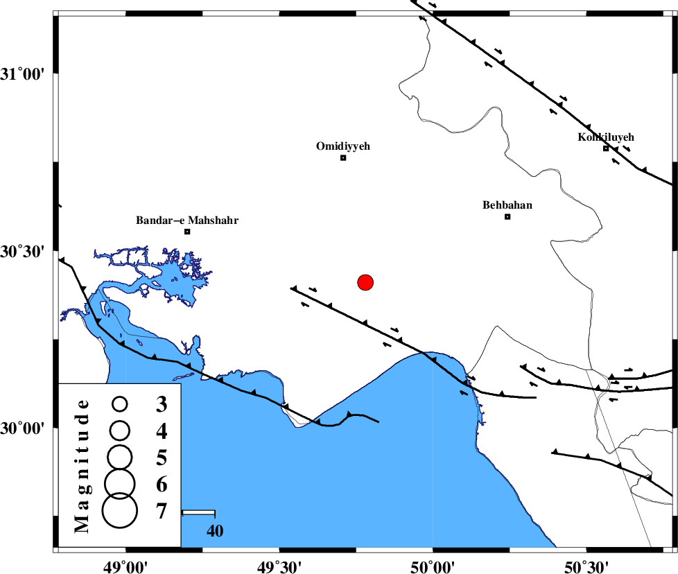
| Date & Time (UTC) | 2015-05-11 09:06:17.1 |
| Date & Time (Local) | 1394/2/21 13:36:17.1 |
| Location | Lat:30.41 Lon: 49.78 |
| Region | Khoozestan Province, 20 km North of Hendijan |
Nearest Cities |
|
| 11 km of Chamkhalf-e eisa, Khoozestan Province | |
| 20 km South of Asiyab, Khoozestan Province | |
| 20 km North of Hendijan, Khoozestan Province | |
| 27 km North West of Darunak, Khoozestan Province | |
| 32 km South of Aghajari, Khoozestan Province | |
| Depth | 14 km |
| Agency | |
Faults within 150 km: |
|
| RAG_E_SEFID_F (Length: 84 km) , Distance to epicenter: 3 km | |
| AGHAJARI_F (Length: 88 km) , Distance to epicenter: 26 km | |
| ZFF3 (Length: 125 km) , Distance to epicenter: 64 km | |
| Number of Phases | 6 |
| RMS | 0.2 |
| Number of Stations | 4 |
| Error in Latitude | >5 km |
| Error in Longitude | 9 km |
| Error in Depth | 4.3 km |
Download waveform in seisan format
to download seisan software Click here
to access information about IIEES stations Click here
Amplitude | ||||||||
| UID | Agency | Station | Component | Amplitude | Period | Arrival Time | Proccessing Time | Signal Clip |
| 95650 | IIEES | SHGR | E | 213.6 | 0.4 | 2015-05-11 09:07:18 | 2015-05-11 11:22:00 | n |
Phase | ||||||||||||
| Agency | Station | Component | Phase Type | Phase Quality | First Motion | Observed Arrival Time | Time Residual | Loc. Flag | Input Weight | Distance | Azimuth | |
| IIEES | SHGR | Z | Pn | E | 2015-05-11 09:06:51 | 0.23 | y | 210 | 334 | |||
| IIEES | SHGR | N | Sg | E | 2015-05-11 09:07:16 | -0.11 | y | 210 | 334 | |||
| IIEES | AHRM | Z | Pn | E | 2015-05-11 09:06:52 | -0.23 | y | 225 | 139 | |||
| IIEES | AHRM | N | Sg | E | 2015-05-11 09:07:20 | 0.11 | y | 225 | 139 | |||
| IIEES | KHMZ | Z | Pn | E | 2015-05-11 09:07:10 | 0.08 | y | 370 | 3 | |||
| IIEES | ASAO | Z | Pn | E | 2015-05-11 09:07:22 | -0.09 | y | 460 | 3 | |||