
Magnitude |
:2.5 |
| Date & Time (UTC) | 2015-04-14 09:53:08.6 |
| Date & Time (Local) | 1394/1/25 14:23:08.6 |
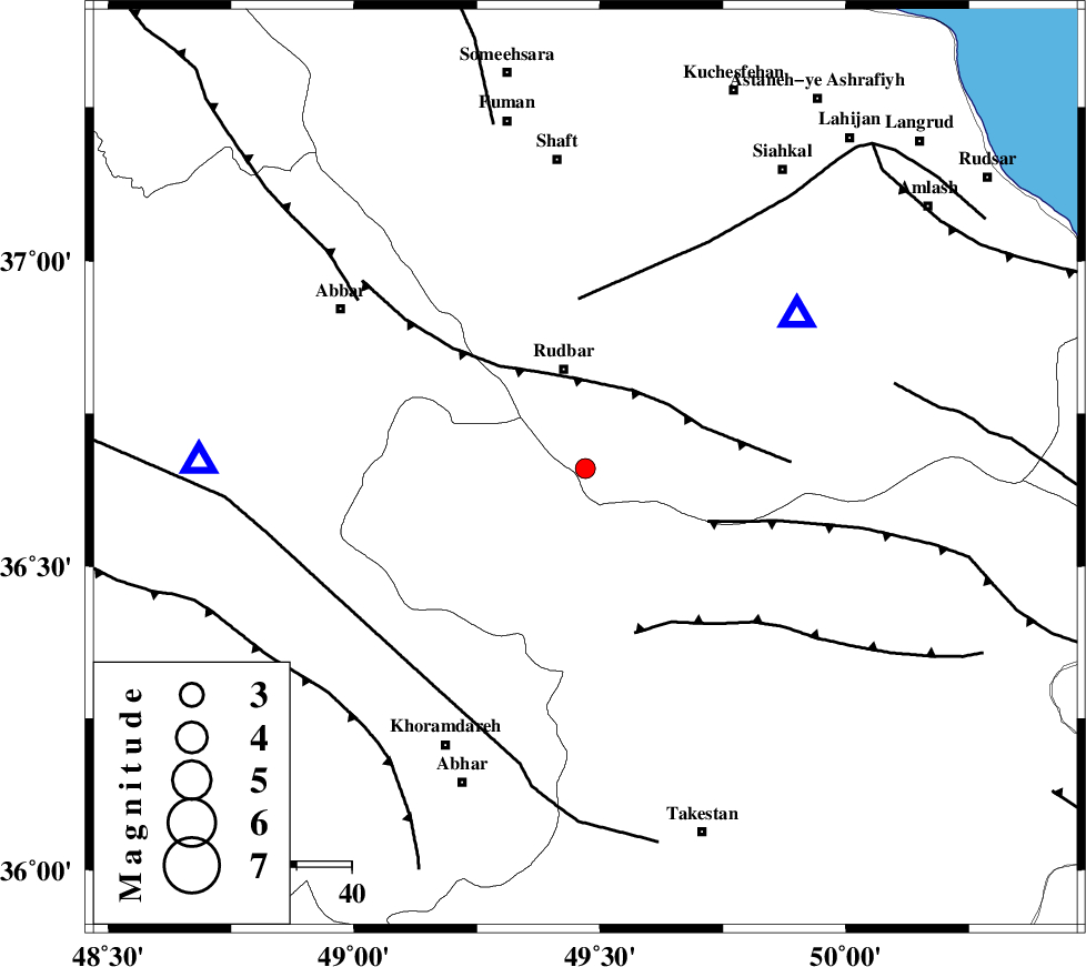
| Location | Lat:36.66 Lon: 49.47 |
| Region | Gilan Province, 18 km South of Rudbar |
Nearest Cities |
|
| 6 km North of Loshan, Gilan Province | |
| 11 km East of Siyahpush, Ghazvin Province | |
| 11 km of Manjil, Gilan Province | |
| 11 km North of Kuhgir-e sofla, Ghazvin Province | |
| 19 km South of Rudbar, Gilan Province | |
| Depth | 14 km |
| Agency | |
Faults within 150 km: |
|
| RUDBAR_F (Length: 93 km) , Distance to epicenter: 17 km | |
| ALAMUTRUD_F (Length: 140 km) , Distance to epicenter: 24 km | |
| LAHIJAN_F (Length: 92 km) , Distance to epicenter: 31 km | |
| Number of Phases | 7 |
| RMS | 0.1 |
| Number of Stations | 4 |
| Error in Latitude | >2 km |
| Error in Longitude | 1.3 km |
| Error in Depth | 4 km |
Download waveform in seisan format
to download seisan software Click here
to access information about IIEES stations Click here
Amplitude | ||||||||
| UID | Agency | Station | Component | Amplitude | Period | Arrival Time | Proccessing Time | Signal Clip |
| 95428 | IIEES | THKV | N | 92.9 | 0.17 | 2015-04-14 09:53:55 | 2015-04-14 10:34:00 | n |
| 95429 | IIEES | CHTH | N | 46.6 | 0.11 | 2015-04-14 09:54:00 | 2015-04-14 10:34:00 | n |
Phase | ||||||||||||
| Agency | Station | Component | Phase Type | Phase Quality | First Motion | Observed Arrival Time | Time Residual | Loc. Flag | Input Weight | Distance | Azimuth | |
| IIEES | ZNJK | Z | Pg | E | 2015-04-14 09:53:20 | -0.1 | y | 69.8 | 271 | |||
| IIEES | ZNJK | N | Sg | E | 2015-04-14 09:53:30 | 0.04 | y | 69.8 | 271 | |||
| IIEES | THKV | Z | Pg | E | 2015-04-14 09:53:34 | 0.17 | y | 152 | 123 | |||
| IIEES | CHTH | Z | Pg | E | 2015-04-14 09:53:36 | -0.1 | y | 171 | 119 | |||
| IIEES | CHTH | N | Sg | E | 2015-04-14 09:53:57 | -0.06 | y | 171 | 119 | |||
| IIEES | ASAO | Z | Pn | E | 2015-04-14 09:53:46 | 0.1 | y | 240 | 168 | |||
| IIEES | ASAO | N | Sg | E | 2015-04-14 09:54:16 | -0.05 | y | 240 | 168 | |||