
Magnitude |
:3.2 |
| Date & Time (UTC) | 2015-04-09 02:22:34.8 |
| Date & Time (Local) | 1394/1/20 06:52:34.8 |
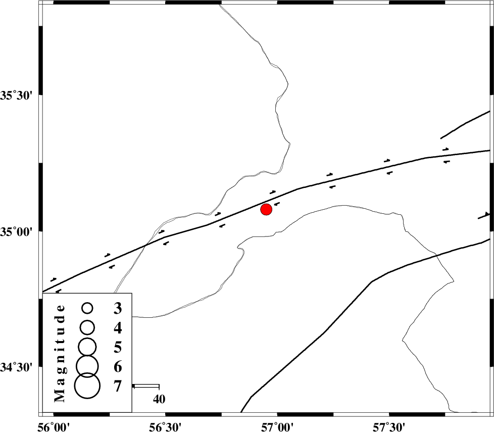
| Location | Lat:35.08 Lon: 56.95 |
| Region | Khorasan(center) Province, 93 km South-West of Bardeskan |
Nearest Cities |
|
| 33 km North West of Tappeh taq, Yazd Province | |
| 59 km South East of Zamanabad, Semnan Province | |
| 80 km North of Eshqabad, Yazd Province | |
| 89 km West of Shahrabad, Khorasan(center) Province | |
| 93 km South West of Bardeskan, Khorasan(center) Province | |
| Depth | 14 km |
| Agency | |
Faults within 150 km: |
|
| DORUNEH_F (Length: 713 km) , Distance to epicenter: 15 km | |
| NAINI_F (Length: 342 km) , Distance to epicenter: 52 km | |
| BIJVARD_F (Length: 83 km) , Distance to epicenter: 76 km | |
| Number of Phases | 6 |
| RMS | 0.1 |
| Number of Stations | 5 |
| Error in Latitude | >2.2 km |
| Error in Longitude | 2.8 km |
| Error in Depth | 5.9 km |
Download waveform in seisan format
to download seisan software Click here
to access information about IIEES stations Click here
Amplitude | ||||||||
| UID | Agency | Station | Component | Amplitude | Period | Arrival Time | Proccessing Time | Signal Clip |
| 95367 | IIEES | SHRT | E | 50.4 | 0.4 | 2015-04-09 02:24:23 | 2015-04-09 02:44:00 | n |
| 95368 | IIEES | SHRT | N | 39.6 | 0.44 | 2015-04-09 02:24:29 | 2015-04-09 02:44:00 | n |
| 95369 | IIEES | YZKH | E | 68 | 0.48 | 2015-04-09 02:24:29 | 2015-04-09 02:44:00 | n |
| 95370 | IIEES | YZKH | N | 81.8 | 0.44 | 2015-04-09 02:24:30 | 2015-04-09 02:44:00 | n |
Phase | ||||||||||||
| Agency | Station | Component | Phase Type | Phase Quality | First Motion | Observed Arrival Time | Time Residual | Loc. Flag | Input Weight | Distance | Azimuth | |
| IIEES | SHRO | Z | Pg | E | 2015-04-09 02:22:57 | -0.15 | y | 134 | 321 | |||
| IIEES | BJRD | Z | Pn | E | 2015-04-09 02:23:19 | -0.03 | y | 294 | 8 | |||
| IIEES | BJRD | N | Sg | E | 2015-04-09 02:23:57 | 0.11 | y | 294 | 8 | |||
| IIEES | SHRT | Z | Pn | E | 2015-04-09 02:23:25 | -0.06 | y | 346 | 116 | |||
| IIEES | YZKH | Z | Pn | E | 2015-04-09 02:23:28 | 0.09 | y | 370 | 217 | |||
| IIEES | KHMZ | Z | Pn | E | 2015-04-09 02:24:04 | 0.12 | y | 659 | 259 | |||