
Magnitude |
:2.9 |
| Date & Time (UTC) | 2015-03-19 20:33:08.6 |
| Date & Time (Local) | 1393/12/29 00:03:08.6 |
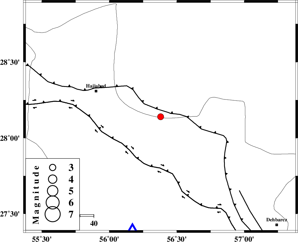
| Location | Lat:28.14 Lon: 56.38 |
| Region | Kerman Province, 51 km South-East of Hajiabad |
Nearest Cities |
|
| 20 km North East of Fareqan, Hormozgan Province | |
| 33 km South of Arzuieeh, Kerman Province | |
| 35 km South of Shahmaran, Kerman Province | |
| 50 km South East of Hajiabad, Hormozgan Province | |
| 54 km South West of Sarkhan, Kerman Province | |
| Depth | 18 km |
| Agency | |
Faults within 150 km: |
|
| MAIN_ZAGROS_R_F (Length: 1106 km) , Distance to epicenter: 7 km | |
| HZF2 (Length: 437 km) , Distance to epicenter: 33 km | |
| ZENDAN_MINAB_F_Z1 (Length: 183 km) , Distance to epicenter: 79 km | |
| Number of Phases | 5 |
| RMS | 0.1 |
| Number of Stations | 4 |
| Error in Latitude | >1.3 km |
| Error in Longitude | 4.1 km |
| Error in Depth | 3.4 km |
Download waveform in seisan format
to download seisan software Click here
to access information about IIEES stations Click here
Amplitude | ||||||||
| UID | Agency | Station | Component | Amplitude | Period | Arrival Time | Proccessing Time | Signal Clip |
| 95270 | IIEES | BNDS | N | 637.3 | 0.28 | 2015-03-19 20:33:36 | 2015-03-19 08:56:00 | n |
| 95271 | IIEES | KRBR | N | 78 | 0.28 | 2015-03-19 20:34:14 | 2015-03-19 08:56:00 | n |
Phase | ||||||||||||
| Agency | Station | Component | Phase Type | Phase Quality | First Motion | Observed Arrival Time | Time Residual | Loc. Flag | Input Weight | Distance | Azimuth | |
| IIEES | BNDS | Z | Pg | E | 2015-03-19 20:33:23 | 0.06 | y | 84.1 | 194 | |||
| IIEES | KRBR | Z | Pn | E | 2015-03-19 20:33:41 | -0.11 | y | 208 | 10 | |||
| IIEES | KRBR | E | Sg | E | 2015-03-19 20:34:08 | 0.11 | y | 208 | 10 | |||
| IIEES | ZHSF | Z | Pn | E | 2015-03-19 20:34:13 | -0.03 | y | 459 | 68 | |||
| IIEES | YZKH | Z | Pn | E | 2015-03-19 20:34:18 | -0.07 | y | 502 | 340 | |||