
Magnitude |
:4 |
| Date & Time (UTC) | 2015-03-02 04:12:47.6 |
| Date & Time (Local) | 1393/12/11 07:42:47.6 |
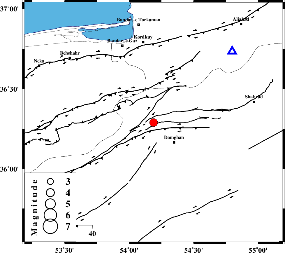
| Location | Lat:36.29 Lon: 54.19 |
| Region | Semnan Province, 20 km North-West of Damghan |
Nearest Cities |
|
| 20 km North West of Damghan, Semnan Province | |
| 26 km North of Seydabad, Semnan Province | |
| 29 km North of Amirabad, Semnan Province | |
| 34 km North West of Mehmandust, Semnan Province | |
| 38 km South West of Cheharbagh, Golestan Province | |
| Depth | 17 km |
| Agency | |
Faults within 150 km: |
|
| ASTANEH_F (Length: 72 km) , Distance to epicenter: 8 km | |
| DAMGHAN_F (Length: 95 km) , Distance to epicenter: 12 km | |
| ATARI_F (Length: 185 km) , Distance to epicenter: 16 km | |
| Number of Phases | 9 |
| RMS | 0.4 |
| Number of Stations | 8 |
| Error in Latitude | >9.3 km |
| Error in Longitude | 3.4 km |
| Error in Depth | 7.3 km |
Download waveform in seisan format
to download seisan software Click here
to access information about IIEES stations Click here
Amplitude | ||||||||
| UID | Agency | Station | Component | Amplitude | Period | Arrival Time | Proccessing Time | Signal Clip |
| 95122 | IIEES | DAMV | E | 768.7 | 0.52 | 2015-03-02 04:13:55 | 2015-03-02 04:46:00 | n |
| 95123 | IIEES | THKV | N | 989.7 | 0.88 | 2015-03-02 04:14:19 | 2015-03-02 04:46:00 | n |
| 95124 | IIEES | GHVR | E | 364.6 | 0.6 | 2015-03-02 04:14:26 | 2015-03-02 04:46:00 | n |
| 95125 | IIEES | GHVR | N | 439.7 | 0.54 | 2015-03-02 04:14:27 | 2015-03-02 04:46:00 | n |
Phase | ||||||||||||
| Agency | Station | Component | Phase Type | Phase Quality | First Motion | Observed Arrival Time | Time Residual | Loc. Flag | Input Weight | Distance | Azimuth | |
| IIEES | SHRO | Z | Pg | E | 2015-03-02 04:13:15 | -0.17 | y | 167 | 100 | |||
| IIEES | DAMV | Z | Pn | E | 2015-03-02 04:13:21 | -0.23 | y | 213 | 251 | |||
| IIEES | DAMV | E | Sg | E | 2015-03-02 04:13:48 | 0.17 | y | 213 | 251 | |||
| IIEES | THKV | Z | Pn | E | 2015-03-02 04:13:32 | 0.4 | y | 301 | 263 | |||
| IIEES | GHVR | Z | Pn | E | 2015-03-02 04:13:36 | -0.22 | y | 335 | 234 | |||
| IIEES | NASN | Z | Pn | E | 2015-03-02 04:13:45 | -0.58 | y | 407 | 199 | |||
| IIEES | ASAO | Z | Pn | E | 2015-03-02 04:13:47 | -0.27 | y | 425 | 244 | |||
| IIEES | YZKH | Z | Pn | E | 2015-03-02 04:13:49 | 0.64 | y | 434 | 175 | |||
| IIEES | SHRT | Z | Pn | E | 2015-03-02 04:14:13 | 0.45 | y | 629 | 116 | |||