
Magnitude |
:2.7 |
| Date & Time (UTC) | 2015-03-01 05:09:18.8 |
| Date & Time (Local) | 1393/12/10 08:39:18.8 |
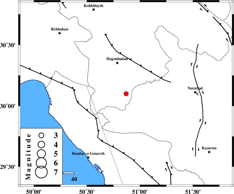
| Location | Lat:30.1 Lon: 50.87 |
| Region | Kohkiluieh va boyerahmad Province, 29 km South of Dogonbadan |
Nearest Cities |
|
| 29 km South of Dogonbadan, Kohkiluieh va boyerahmad Province | |
| 32 km North West of Babamonir, Fars Province | |
| 40 km South West of Basht, Kohkiluieh va boyerahmad Province | |
| 43 km South West of Abdehgah, Kohkiluieh va boyerahmad Province | |
| 49 km South West of Kopon olia, Fars Province | |
| Depth | 14 km |
| Agency | |
Faults within 150 km: |
|
| MISHAN_F (Length: 76 km) , Distance to epicenter: 29 km | |
| ZFF3 (Length: 125 km) , Distance to epicenter: 35 km | |
| RAG_E_SEFID_F (Length: 84 km) , Distance to epicenter: 48 km | |
| Number of Phases | 5 |
| RMS | 0.1 |
| Number of Stations | 4 |
| Error in Latitude | >1.7 km |
| Error in Longitude | 4.4 km |
| Error in Depth | 7 km |
Download waveform in seisan format
to download seisan software Click here
to access information about IIEES stations Click here
Amplitude | ||||||||
| UID | Agency | Station | Component | Amplitude | Period | Arrival Time | Proccessing Time | Signal Clip |
| 95116 | IIEES | AHRM | N | 109.9 | 0.55 | 2015-03-01 05:10:08 | 2015-03-01 07:00:00 | n |
| 95117 | IIEES | SHGR | N | 37.8 | 0.7 | 2015-03-01 05:10:46 | 2015-03-01 07:00:00 | n |
| 95118 | IIEES | SHGR | E | 34.4 | 0.44 | 2015-03-01 05:10:50 | 2015-03-01 07:00:00 | n |
Phase | ||||||||||||
| Agency | Station | Component | Phase Type | Phase Quality | First Motion | Observed Arrival Time | Time Residual | Loc. Flag | Input Weight | Distance | Azimuth | |
| IIEES | AHRM | Z | Pg | E | 2015-03-01 05:09:42 | -0.09 | y | 143 | 163 | |||
| IIEES | AHRM | N | S | E | 2015-03-01 05:09:59 | 0.07 | y | 143 | 163 | |||
| IIEES | SHGR | E | Sg | E | 2015-03-01 05:10:42 | 0 | y | 297 | 319 | |||
| IIEES | NASN | Z | Pn | E | 2015-03-01 05:10:10 | 0.1 | y | 351 | 31 | |||
| IIEES | YZKH | Z | Pn | E | 2015-03-01 05:10:20 | -0.09 | y | 436 | 54 | |||