
Magnitude |
:3.1 |
| Date & Time (UTC) | 2015-02-25 14:43:26.5 |
| Date & Time (Local) | 1393/12/6 18:13:26.5 |
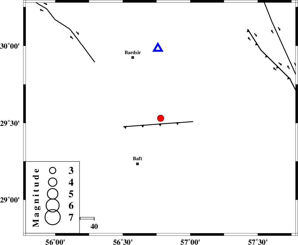
| Location | Lat:29.53 Lon: 56.78 |
| Region | Kerman Province, 37 km North-East of Baft |
Nearest Cities |
|
| 4 km North of Lalehzar, Kerman Province | |
| 11 km North East of Ghale-ye asgar, Kerman Province | |
| 24 km North East of Karin, Kerman Province | |
| 25 km North of Askar, Kerman Province | |
| 25 km North West of Siyah bonueyeh, Kerman Province | |
| Depth | 26 km |
| Agency | |
Faults within 150 km: |
|
| LALEHZAR_F (Length: 52 km) , Distance to epicenter: 23 km | |
| RAFSANJAN_F (Length: 129 km) , Distance to epicenter: 62 km | |
| GOWK_F (Length: 152 km) , Distance to epicenter: 87 km | |
| Number of Phases | 6 |
| RMS | 0.1 |
| Number of Stations | 5 |
| Error in Latitude | >1.3 km |
| Error in Longitude | 3.2 km |
| Error in Depth | 7.3 km |
Download waveform in seisan format
to download seisan software Click here
to access information about IIEES stations Click here
Amplitude | ||||||||
| UID | Agency | Station | Component | Amplitude | Period | Arrival Time | Proccessing Time | Signal Clip |
| 95100 | IIEES | KRBR | E | 549.2 | 0.56 | 2015-02-25 14:43:57 | 2015-02-25 03:10:00 | n |
| 95101 | IIEES | BNDS | N | 198.6 | 0.32 | 2015-02-25 14:44:31 | 2015-02-25 03:10:00 | n |
| 95102 | IIEES | BNDS | E | 169.1 | 0.56 | 2015-02-25 14:44:34 | 2015-02-25 03:10:00 | n |
Phase | ||||||||||||
| Agency | Station | Component | Phase Type | Phase Quality | First Motion | Observed Arrival Time | Time Residual | Loc. Flag | Input Weight | Distance | Azimuth | |
| IIEES | BNDS | Z | Pn | E | 2015-02-25 14:44:03 | 0.11 | y | 244 | 194 | |||
| IIEES | BNDS | N | S | E | 2015-02-25 14:44:30 | -0.09 | y | 244 | 194 | |||
| IIEES | BSRN | Z | Pn | E | 2015-02-25 14:44:16 | -0.17 | y | 351 | 39 | |||
| IIEES | YZKH | Z | Pn | E | 2015-02-25 14:44:20 | -0.1 | y | 380 | 327 | |||
| IIEES | YZKH | N | S | E | 2015-02-25 14:44:59 | 0.11 | y | 380 | 327 | |||
| IIEES | ZHSF | Z | Pn | E | 2015-02-25 14:44:21 | 0.15 | y | 387 | 88 | |||